The Relationship between Forest Fires and Deforestation in the Amazon: Phenomena Are More Closely Related in Rural Settlements and in Occupied Public Lands
INTRODUCTION
Between 2013 and 2020, on average, about 42% of active fires[1] in the Brazilian Amazon happened in areas that had never been deforested, according to data from the National Institute for Space Research (Instituto Nacional de Pesquisas Espaciais – INPE). Estimates suggest that these fires might have affected more than 18,000 square kilometers of forest cover each year, which is more than double the deforested area in the same period.[2]
Forest fires cause significant environmental damage, even when they do not effectively clear the affected areas. Not only do fires make forests less resilient to future damage, but they also interfere in the provision of ecosystem services, compromising forests’ ability to capture and store carbon.[3] If fires are systematically used to make way for deforestation, their occurrence could serve as a leading indicator of more severe environmental damage. In this case, combating fires could enhance forest protection by halting its damage while in an early stage, and thereby avoiding future deforestation. Forest fires are, therefore, a central topic for conservation public policy. A deeper understanding of the phenomenon is key for improving policy design and execution.
Climate Policy Initiative/Pontifical Catholic University of Rio de Janeiro (CPI/PUC-Rio) is conducting a series of studies about forest degradation in the Amazon.[4],[5] This document presents the main findings from an analysis of the occurrence of forest fires and their relationship with subsequent deforestation. Results reveal that, on average, only 11% of the forest area affected by fire is deforested within three years. This indicates that forest fires in the Amazon are not systematically used as a first step towards removing vegetation, which emphasizes the importance of further investigating the reasons behind this phenomenon. While fires destroy valuable environmental assets, they apparently do not lead to the full conversion of forested areas to alternative land uses.
Nevertheless, the evidence suggests that fires may serve as a leading indicator for more severe damage to forests and biodiversity in a given region. For a substantial proportion of areas affected by fire, deforestation follows in its immediate vicinity – i.e., there is a high probability of observing deforestation close to areas affected by fires after they occur. This relationship varies, however, across land tenure categories and states.[6] Occupied public lands (areas inside undesignated public forests that were registered as private lands) and rural settlements exhibit an association between fires and subsequent deforestation in their vicinities about 35% stronger than the average observed in other land tenure categories. This pattern suggests that forest fires might play an important role in land grabbing, likely as a low-cost and quick way of occupying public lands.
Furthermore, some states present a noticeable increase in the association between fire and deforestation in recent years, especially Acre. This reinforces the need to approach forest protection with policies that account for regional and local heterogeneities, such as land governance models and institutional capabilities.
FIRE IN THE BRAZILIAN AMAZON
Natural fire is a rare phenomenon in tropical forests due to their high humidity.[7] Hence, fires in the Amazon are usually the result of human activity.[8] In previously deforested areas, fire is typically used to burn remaining biomass or as a land management technique for agriculture and cattle production.[9] Since these areas have already lost all – or nearly all – of their native vegetation, these fires are not considered to be forest degradation. However, fires also occur in forests, either because of intentional practices or accidental spillover from deforested areas.[10] In these cases, fires destroy the most vulnerable trees and plants, compromising the resilience of the surviving vegetation and making it more susceptible. Indeed, fires not only cause a loss of vegetation while they are actively burning, but also for a long period afterwards.[11] This partial loss of vegetation can be categorized as forest degradation.
To measure the occurrence of fires, this study uses data from INPE’s Fire Program (Programa Queimadas), with daily observations of active fires covering the entire Brazilian Amazon detected by a VIIRS sensor onboard the Suomi-NPP satellite. According to this database, around 42% of active fires registered between 2013 and 2020 were in forested areas, whereas 58% were in deforested areas. This study only considers fires located inside forests that have never been deforested in the Amazon biome as signs of forest degradation.[12]
FIRE AND DEFORESTATION
Between 2013 and 2020, forest area affected by fire in the Amazon was consistently larger than that which was deforested. It is estimated that fires may have affected more than 18,000 square kilometers of forest per year – more than twice the annual average of deforestation. Nonetheless, there seems to be low conversion from fire to deforestation in this period. On average, only 11% of the forest area affected by fire was deforested within three years.[13] However, because this is an average for all the Amazon, the low conversion rate might hide important differences in the dynamics of fire and deforestation across regions. This study, therefore, explores how the relationship between these two phenomena varies across land tenure categories and states in the Amazon.
FIRE AND DEFORESTATION ACROSS LAND TENURE CATEGORIES
By focusing on land tenure categories,[14] the analysis aims at grouping territories that are under similar norms and regulations regarding land use. Figure 1 presents the distribution of forest fires and deforestation across land tenure categories. The percentages represent the share of the total area affected by fire and deforestation between 2013 and 2020 occurring inside each category. For example, approximately 24% of the deforested area and 20% of the forest area affected by fire were concentrated in rural settlements in that period. Noticeably, both phenomena have similar distributions, i.e., forest fires tend to be concentrated in the same categories as deforestation. Specifically, both are mainly concentrated in medium or large private properties and rural settlements.
Figure 1. Distribution of Fire and Deforestation Across Land Tenure Categories
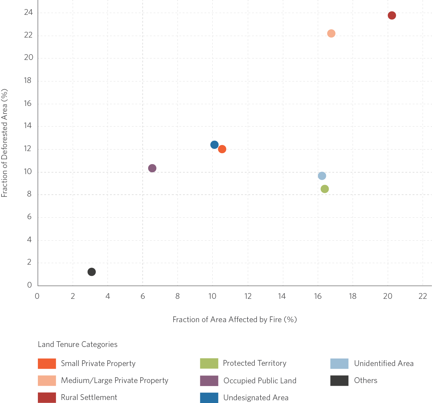
Note: The percentages represent the share of total forest areas affected by fire or deforestation between 2013 and 2020 that are in each land tenure category.
Source: CPI/PUC-Rio with data from Programa Queimadas/INPE, PRODES/INPE, Atlas Agropecuário/Imaflora and Cadastro Nacional de Florestas Públicas/Serviço Florestal Brasileiro, 2021.
The distribution pattern across land tenure categories suggests that forest fires and deforestation might be connected.[15] Figure 2 explores this potential association by showing the deforestation that happened in the same place as the forest fire (local conversion) and the deforestation that happened in the vicinity of areas affected by forest fires. Local conversion from fire to deforestation is relatively low across all land tenure categories, with less than 20% of the forest area affected by fires being deforested within three years. This indicates that forest fires in the Amazon are not systematically serving as an initial stage of deforestation, reinforcing the relevance of understanding their drivers to advance knowledge about forest degradation.
Figure 2. Relationship between Fire and Subsequent Deforestation by Land Tenure Category, 2013 – 2018
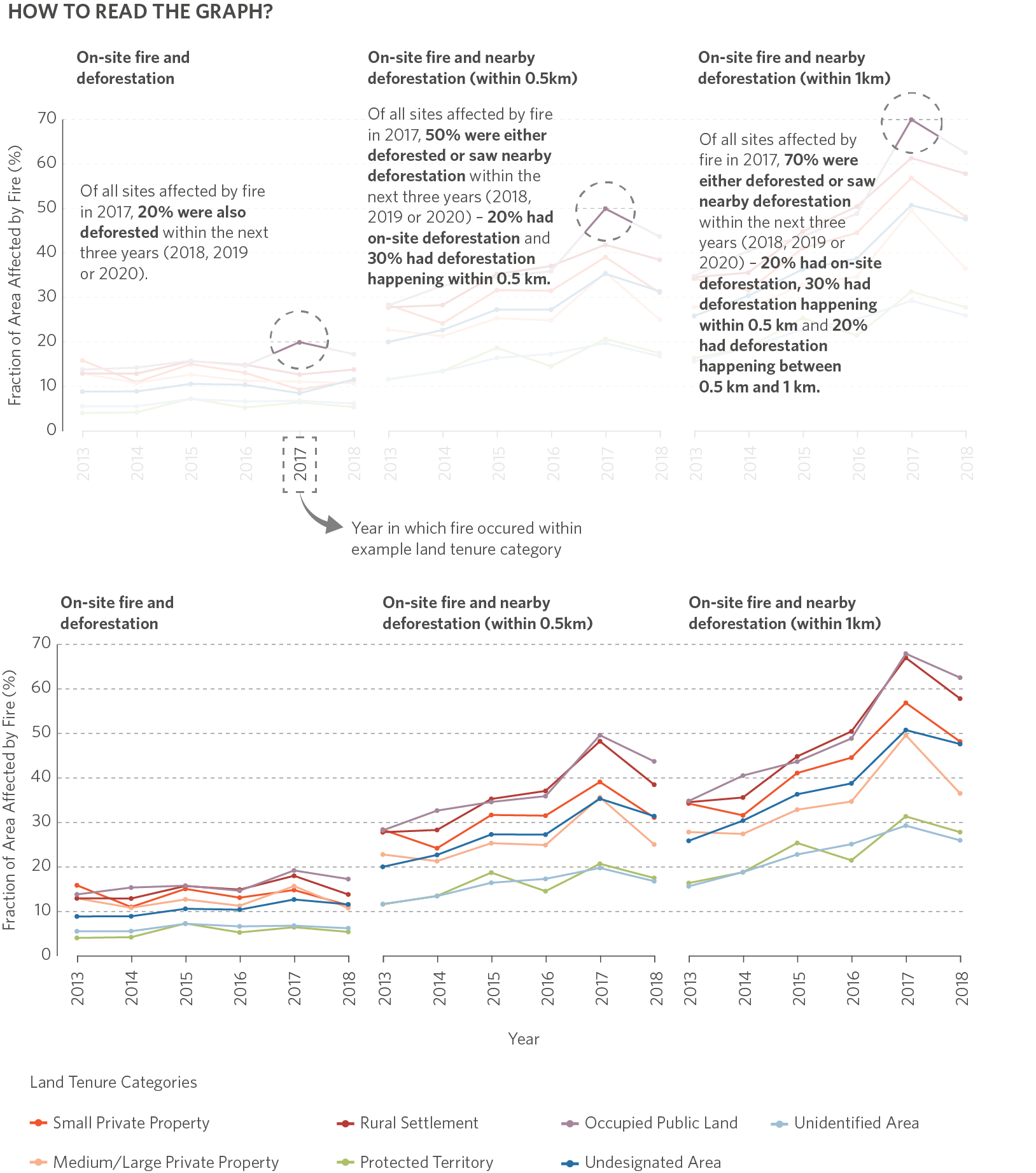
Note: The graph shows the share of forest area affected by fire in each year and land tenure category that was followed by deforestation within three years. The analysis ends in 2018, as the last year of available spatial information for deforestation is 2020. The analysis considers deforestation happening in the same place as fires (local conversion of fire to deforestation) and in their vicinity (deforestation near fire).
Source: CPI/PUC-Rio with data from Programa Queimadas/INPE, PRODES/INPE, Atlas Agropecuário/Imaflora and Cadastro Nacional de Florestas Públicas/Serviço Florestal Brasileiro, 2021
However, the data points to substantial deforestation happening after fires in the vicinity of areas affected by them. As an example, the percentage of areas affected by fire with subsequent deforestation within 0.5 kilometers ranged from 20% to 50% in 2017. Hence, although fires might not be a leading indicator of deforestation in the same area, they could serve as a sign that a region is under imminent risk of deforestation.
Figure 2 also indicates that the relationship between fires and deforestation varies significantly across land tenure categories. Rural settlements and occupied public lands consistently exhibit a stronger association between fires and nearby deforestation. From a policymaking perspective, regions affected by fires in those categories should be considered critical areas for prioritizing efforts to combat deforestation.
Finally, results for occupied public lands could be hinting at how the process of land grabbing might unfold, since this category comprises undesignated public forests that were registered as private lands.[16] In this case, maybe fires allow for a rapid and low-cost occupation of forested areas. Although only suggestive, this finding points to a potential benefit of learning more about the economic motivations of land grabbers and the instruments they use to environmental control policies.
FIRE AND DEFORESTATION ACROSS STATES
State-specific trajectories shed light on potential heterogeneities in the association between forest fires and deforestation at a regional level. Noticeably, states with a higher concentration of forest fires are also those with more deforestation (Figure 3). Between 2013 and 2020, Pará accounted for 33% of all forest fires and 39% of the total deforested area; in Mato Grosso, those shares amounted to 18% and 23%, respectively.
Figure 3. Distribution of Fire and Deforestation across States
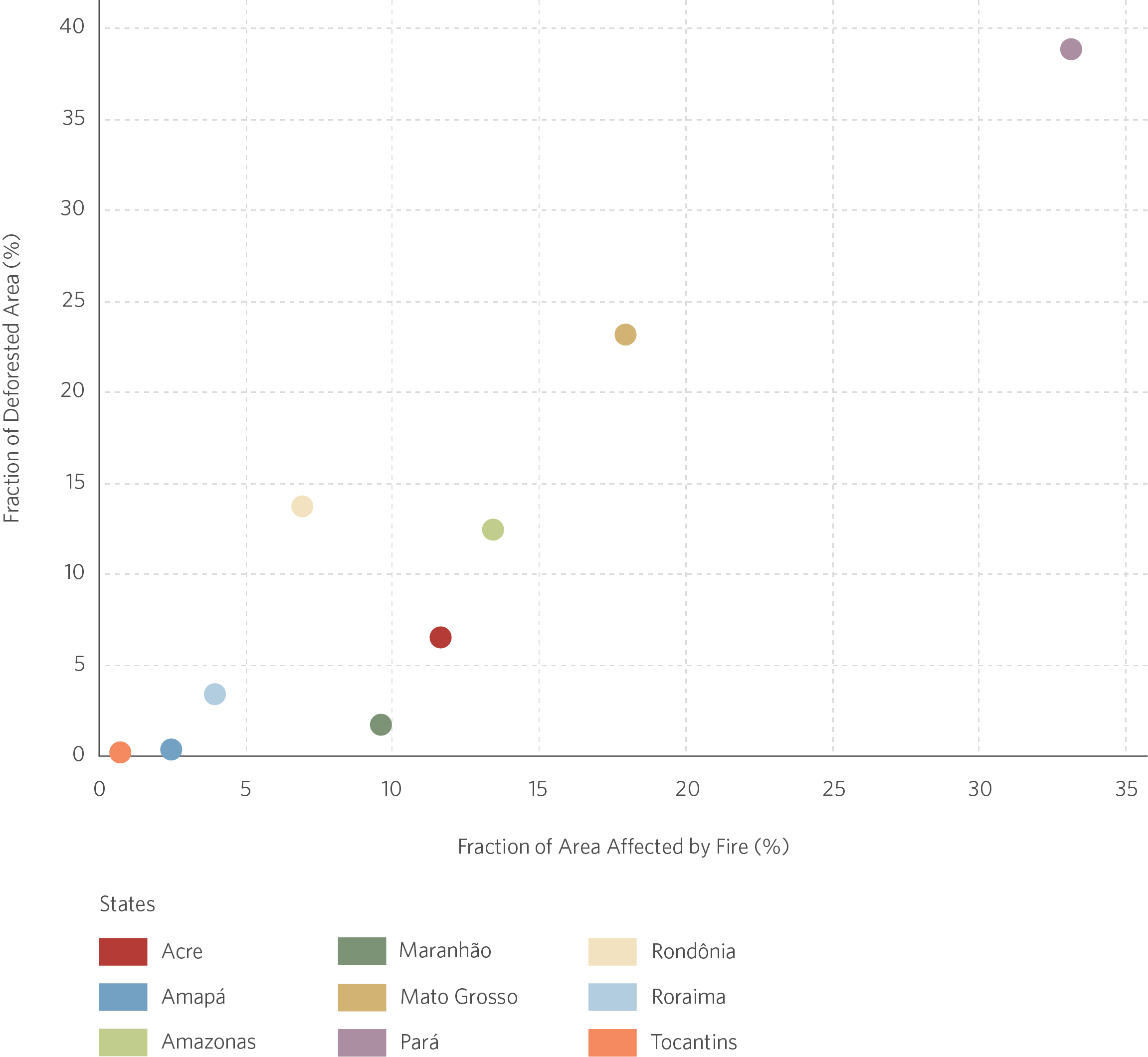
Note: The percentages represent the share of total forest areas affected by fire or deforestation between 2013 and 2020 that are in each state. The analysis only considers the regions of the state that are within the Amazon biome.
Source: CPI/PUC-Rio with data from Programa Queimadas/INPE, PRODES/INPE, Atlas Agropecuário/Imaflora and Cadastro Nacional de Florestas Públicas/Serviço Florestal Brasileiro, 2021
Figure 4. Relationship between Fire and Subsequent Deforestation by States, 2013 – 2018
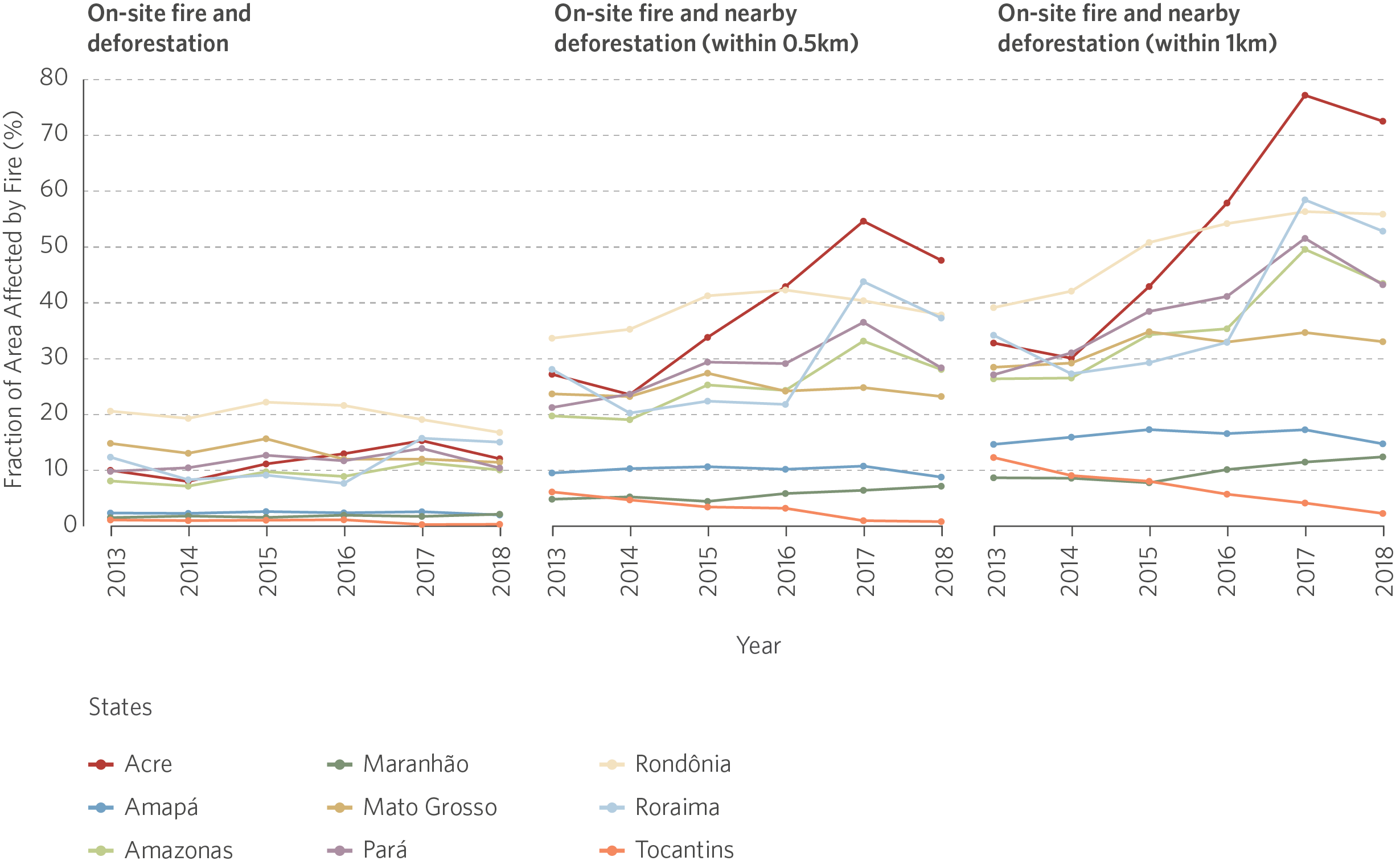
Note: The graph shows the share of forest area affected by fire in each year and state that was followed by deforestation within three years. The analysis ends in 2018, as the last year of available spatial information for deforestation is 2020. The analysis considers deforestation happening in the same place as fires (local conversion of fire to deforestation) and in their vicinity (deforestation near fire). For more details, see How To Read The Graph on Figure 2. This figure is read analogously.
Source: CPI/PUC-Rio with data from Programa Queimadas/INPE, PRODES/INPE, Atlas Agropecuário/Imaflora and Cadastro Nacional de Florestas Públicas/Serviço Florestal Brasileiro, 2021
Figure 4 suggests that there is relatively low conversion of fire to deforestation across all states in the Amazon. Nevertheless, as seen with land tenure categories, there seems to be a fairly high probability of observing subsequent deforestation in the vicinity of areas affected by forest fires.
Moreover, the figure shows that this association varies not only across states, but also over time. The relationship between fires and subsequent nearby deforestation grows stronger in Acre, Amazonas, Pará, Rondônia, and Roraima, peaking in 2017. This pattern contrasts with that observed in the remaining states, where this relationship remains relatively stable. Yet, among these, only Mato Grosso accounts for a substantial share of both forest fires and deforestation (Figure 3).
Differences across states may stem from a variety of factors. First, there are important variations in land tenure structure across regions. For example, Amazonas has a much larger area of undesignated public forests that are potentially under threat of land grabbing than Mato Grosso does. Second, these differences could be associated with state governments’ ability to exert environmental control. Third, leading economic activities may influence the local dynamics of forest conversion. The stability observed in Mato Grosso, for example, may be linked with agricultural activities that are relatively more consolidated in this state. Although it is important to deepen the understanding of the reasons driving the different state trajectories, results suggest that there are regions where combatting fire and associated deforestation has become an increasingly more urgent matter.
NEXT STEPS FOR RESEARCH AND POLICY
This analysis shows that forest fires in the Amazon do not seem to be primarily aimed at removing vegetation. However, although the conversion of fire to deforestation in the same area is relatively uncommon, the evidence suggests that areas close to fires are at imminent risk of deforestation. This result varies across land tenure categories, with the association between fires and deforestation being particularly strong in rural settlements and occupied public lands. This indicates that it could be possible to use the distribution of fires across land tenure categories as relevant criteria to prioritize environmental control efforts targeting deforestation. It is worth noting that Brazil already has an official system that detects active fires and provides daily information regarding their occurrence.
Combined with the heterogeneity in the association between fire and deforestation across states, these results highlight the relevance of improving the knowledge about the drivers of forest fires and the ability of authorities to respond to them in different regions of the Amazon. Moreover, further investigation is needed to understand why a practice as destructive as forest fires is so widely used in the Amazon if the main objective does not seem to be removing forest biomass.
DATA
This analysis explores a rich dataset with spatially explicit (raster) data created based on several publicly available sources. The main variables and their sources are as follows: active fires from Programa Queimadas/INPE; annual deforestation increments from PRODES/INPE; land tenure categories from both the Atlas Agropecuário/Imaflora and the Cadastro Nacional de Florestas Públicas/Serviço Florestal Brasileiro.
METHODOLOGICAL NOTE
This study analyzes fires that occur in Amazon Forest areas that have never been deforested to investigate their relationship with clear-cut deforestation between 2013 and 2020 (PRODES-years). The database is in raster format with 30-meter resolution and comprises georeferenced data on active fires and deforestation over time, as well as land tenure categories for the entire Amazon biome.
The data on active fires comprises only those occurrences inside forest areas. The original data provide the centroid of a cell measuring 375 meters by 375 meters within which there was a flaming front. It is not possible to identify the total area actually affected by fire in this cell. Calculations of potentially impacted areas assume that the entire cell was hit by fire and thus provide an upper bound for the actual area affected.
The analysis relates forest fires and deforestation events that happened either in the same area or close to one another, stratifying the results by land tenure categories and by states. Finally, because of the large number of observations (more than one billion cells), the spatial cells considered in this study are a randomly selected sample amounting to 5% of the universe of cells.
The authors would like to thank Juliano Assunção, Natalie Hoover El Rashidy and Giovanna de Miranda for the editing and revision of the text and Meyrele Nascimento and Nina Oswald Vieira for formatting and graphic design.
[1] It’s important to differentiate two concepts related to forest fires: “Forest Fire Burned Area” and “Active Fire”. “Forest Fire Burned Area” denotes the visual footprint left by forest fires and it is detected by optical sensors in satellites. Conversely, “Active Fire” is registered in the moment when forest fires are happening and it is detected by thermal sensors in satellites. Typically, “Forest Fire Burned Areas” are caused by “Active Fires”, but not all “Active Fires” leave visual traces such a “Forest Fire Burned Area”.
[2] Due to methodological details, the data do not allow for the calculation of the exact areas affected by fires. Based on the occurrence of the active fires, it is possible to estimate the potential area affected by them. It is possible, however, that the affected area is smaller than this estimated area. For more details, refer to the methodological note at the end of this document.
[3] Feng, Xiao, Cory Merow, Zhihua Liu et al. “How deregulation, drought and increasing fire impact Amazonian biodiversity”. Nature 597 (2021): 516–521. bit.ly/2ZEsI2p.
[4] Gandour, Clarissa, Diego Menezes, João Pedro Vieira, and Juliano Assunção. Forest Degradation in the Brazilian Amazon: Public Policy Must Target Phenomenon Related to Deforestation. Rio de Janeiro: Climate Policy Initiative, 2021. bit.ly/3rkHzKM.
[5] Pucci, Rafael, Diego Menezes, João Mourão, and Clarissa Gandour. Through DETER’s Lens: The Relationship between Degradation and Deforestation in the Amazon. Rio de Janeiro: Climate Policy Initiative, 2021. bit.ly/ThroughDETERsLens.
[6] “Land Tenure Categories” denotes the type of land governance. Each category has specific characteristics depending on ownership (public or private), management (group or individual), and on whether the land is linked to a governmental agency. Moreover, each category is governed by specific legislation. In this study, land tenure categories are as follows: Small/Medium/Large Private Property, Protected Territory, Rural Settlement, Undesignated Area, Occupied Public Land, Unidentified Area, and Others.
[7] Ray, David, Daniel Nepstad, and Paulo Moutinho. “Micrometeorological and Canopy Controls of Fire Susceptibility in a Forested Amazon Landscape”. Ecological Applications 15, nº 5 (2005): 1664–1678. bit.ly/3DlepO9.
[8] Berenguer, Erika, Nathália Carvalho, Liana O. Anderson, Luiz E. O. C. Aragão, Filipe França, and Jos Barlow. “Improving the spatial-temporal analysis of Amazonian fires”. Global Change Biology 27 (2021): 469-471. bit.ly/3d4UCHV.
[9] Barlow, Jos, Erika Berenguer, Rachel Carmenta, and Filipe França. “Clarifying Amazonia’s burning crisis”. Global Change Biology 26 (2020): 319-321. bit.ly/3xFzdyp.
[10] Alencar, Ane, Lucas Rodrigues, and Isabel Castro. Amazônia em Chamas – O Que Queima, e Onde: Nota Técnica nº 5. Brasília: Instituto de Pesquisa Ambiental da Amazônia, 2020. bit.ly/3rhX8TF.
[11] Barlow, Jos, Carlos A. Peres, Bernard O. Lagan, and Torbjorn Haugaasen. “Large tree mortality and the decline of forest biomass following Amazonian wildfires”. Ecology Letters 6 (2003): 6-8. bit.ly/3FVOAWg.
[12] Other types of forest degradation, such as selective extraction, are not considered in this study.
[13] For cases in which fire is followed by deforestation, the data suggest that the average interval between these two events is three years.
[14] This analysis considers eight land tenure categories: small private properties, medium or large private properties, protected territories (protected areas and indigenous lands), rural settlements, undesignated areas, occupied public lands – areas registered under the Rural Environmental Registry (Cadastro Ambiental Rural – CAR) in undesignated public forests –, unidentified areas – areas for which there is insufficient information about land tenure – and others, which is a residual category.
[15] This study only considers fires that happen inside forest areas that have never been deforested, thus ruling out the possibility that these fires are mechanically linked with deforestation as a final stage of clearing or used as land management techniques in previously cleared areas.
[16] The occurrence of fire and deforestation in undesignated areas is also indicative of land grabbing. This discussion focuses on occupied public lands because these areas have been registered as private lands under CAR even though they are known to be public.
