Governance, Area of Influence, and Environmental Risks of Transport Infrastructure Investments: Case Studies in the State of Pará
Introduction
Federal infrastructure projects use land that belongs to states and municipalities without necessarily consulting them formally about the work that will be carried out. However, like any major work, these projects cause both positive and negative impacts on territories and their respective populations.
Promoting a dialogue with the Brazilian Federal Government is essential for state and municipal governments to develop actions to avoid or mitigate the negative effects of such projects or even compensate adversely affected populations. Before local governments can take a position; however, they must be aware of federal infrastructure planning in their lands, as well as potential issues that maybe be related to the infrastructure projects like governance, areas of influence, and possible impacts.
Using methodologies developed by researchers from Climate Policy Initiative/Pontifical Catholic University of Rio de Janeiro (CPI/PUC-Rio), this study compiles a detailed overview of the four key federal infrastructure projects – either planned or being upgraded – in the state of Pará: Ferrogrão and BR-155/158, not yet started, and BR-163/230/MT/PA and BR-230, which are currently in the process of improvement. This overview will help the state government understand the cycle of these projects, their potential impacts, and potential points for discussion with the Federal Government. In addition to providing a general summary, this document also covers each of the four case studies in greater depth. This work draws on two basic methodologies: the methodology for mapping the project cycle to identify opportunities for dialogue with the Federal Government; and the market access approach used to identify areas of influence and expected impacts of projects under consideration.[1]
To illustrate the relevance of these federal projects for the state of Pará, CPI/PUC-Rio (i) analyzed the project life cycles and socio-environmental studies to identify areas that could be strengthened, and (ii) quantified the deforestation potential of each project.
Project Life Cycle
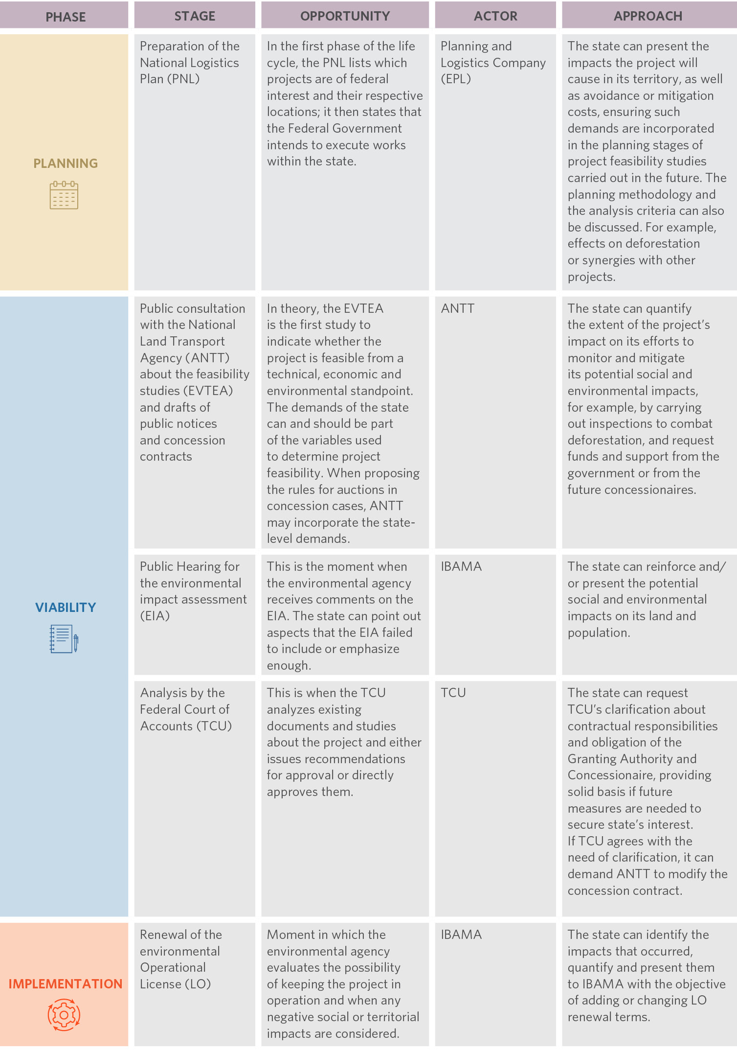
The first step in understanding a project is knowing where it currently stands in its life cycle. In this sense, each project is represented in a flowchart that shows: (i) which stages the project will go through; (ii) which stages it has already completed; (iii) which documents are available in each stage; and (iv) the current stage of the project. The second step is knowing the most opportune moment for dialogue and with whom to interact. The third step is understanding what to approach at each given moment. Along these lines, the table below shows an overview of these steps.
In the case of federal public works, there is also a discussion about budget – specifically, the preparation and approval of the Annual Multi-Year Plan (Plano Plurianual Anual – PPA), the Budget Guidelines Law (Lei de Diretrizes Orçamentárias – LDO) and the Annual Budget Law (Lei Orçamentária Anual – LOA), in which members of parliament for the state of Pará can express their state’s local interests.
In addition to these specific opportunities, political coordination may happen at any time and at any stage of a given project, especially when it is still in the planning stage or at the beginning of the viability phase, as it is more cost effective to modify projects at these stages than after project implementation begins. It should be noted that the Ministry of Economy’s Special Secretariat for the Investment Partnership Program (Programa de Parcerias de Investimentos – PPI) plays a key role in liaising between the state and the private sector and is a crucial player in making federal concessions work. While there is no specific moment in a project’s life cycle when the PPI is to be involved, it remains an important actor from a political liaison perspective.
Opportunities for Dialogue with the Federal Government
During the analysis of CPI/PUC-Rio, obtaining information from documents and socio-environmental studies was difficult – access was limited or documents were unavailable, highlighting a transparency problem. Lack of transparency in the process is not exclusive to the land During the analysis of CPI/PUC-Rio, obtaining information from documents and socio-environmental studies was difficult – access was limited or documents were unavailable, highlighting a transparency problem. Lack of transparency in the process is not exclusive to the land transport sector and clearly limits the ability of civil society, academia, and other state or federal entities in evaluating and monitoring projects.[2] More generally, there are potential costs for society and taxpayers, as large projects are directly and indirectly dependent on public funds and, as such, should be subject to scrutiny by society at all times.
CPI/PUC-Rio also studied the criteria used by the projects to assess social and environmental components. To this end, CPI/PUC-Rio analyzed the Terms of Reference (TR) for the Technical, Economical and Environmental Feasibility Studies (Estudos de Viabilidade Técnica, Econômica e Ambiental – EVTEA), the manual for preparing EVTEA used by the National Department for Transport Infrastructure (Departamento Nacional de Infraestrutura de Transporte – DNIT), as well as international guides on the verification of socio-environmental components in railroads. CPI/PUC-Rio’s researchers identified ten components that are always included, which highlights their importance when designing such studies.[3],[4],[5],[6],[7],[8],[9]
The Market Access Approach
The construction or improvement of transport infrastructure – such as highways, railroads, or waterways – reduces freight costs for rural producers in the regions where the projects are built. The decrease in transport costs makes producers – or their trade partners – more competitive and able to reach new consumer markets, which can prompt rural producers to expand their production. Production can also be increased through different margins: in the intensive margin, lower transportation costs can lead to a better allocation of resources and higher technology uptake; in the extensive margin, however, production increases generate pressure to convert forests into pastures or agricultural areas. Finally, increasing production and decreasing costs can increase land prices, profits, and wages. These are the local – or even direct – effects of transport infrastructure.
Additionally, investments in transport infrastructure can have several indirect effects on locations beyond the reach of lower transport costs. First of all, the aforementioned increase in local wages can lead to migration. On the other hand, the rise in local wages increases demand for products from other regions. These other regions see an increase in production and wages, which generates growth that feeds back across regions connected by trade. Additionally, consumers in regions indirectly affected by the project benefit from lower prices of goods produced in regions directly affected by the project. Finally, producers in regions not directly affected by the project suffer increased competition from producers in regions directly affected by it.
Literature on international trade and economic geography uses a market access approach that enables an analysis of global effects of transport network changes on producers and consumers. These various effects can be summarized using an accessibility metric known as “market access”. This measure can be constructed with information on transport costs in all municipalities and relevant markets.
In an innovative application, CPI/PUC-Rio researchers adapted the market access approach to quantify the effects of building highways, railroads, or waterways on deforestation. This methodology is based on the three steps described further below. The analysis identifies transport infrastructure built or improved over time to determine the costs of bilateral trade. Geoprocessing tools and freight information on various agricultural products are used to generate bilateral transport cost data on all Brazilian municipalities and between the municipalities and their nearest ports from 1990 to 2010.
1. Bilateral transport costs are constructed and combined with municipal population measures to create market access measures for each municipality. Municipalities with higher transport costs are less competitive and can reach fewer markets with their products, so their market access is more limited. The analysis shows that the construction and/or paving of highways considerably improves market access not only for municipalities located around the investment, but also for municipalities that are not located directly around the project. This suggests that this approach can identify areas of indirect influence much more accurately than other approaches that only use project distance metrics to identify such areas. A broader identification of areas of influence reflects the ability of the market access measure to encompass multiple dimensions in which changes to transport costs can affect economic dynamics.
2. An econometric model is used to estimate the response of agricultural expansion to changes in market access in municipalities in the Legal Amazon by combining market access data with georeferenced information on land use from 1990 to 2019. This model found that a 1% increase in market access increases deforestation by 0.5%.
3. Planned infrastructure projects are inserted into the transport network. New projects change the cost of transport and, consequently, market access as well. A project’s area of influence can be determined by comparing market access rates with and without the project. A project’s deforestation risk and the cost of mitigating it can be calculated by combining the area of influence with the deforestation response to changes in market access.
This step-by-step process is a way to determine areas of influence and quantify environmental risks much more precisely than the current approach, which uses distance-related criteria exclusively. Applying this methodology to projects in the state of Pará provides an insight into the extent and dimension of the impacts of federal logistics infrastructure projects on conservation efforts in the state of Pará.
MAIN RESULTS
The mapping of the project cycle reveals that:
• the four projects under analysis (Ferrogrão, BR-155/158, BR-163/230/MT/PA, BR-230) did not necessarily follow a logical order in their life cycle stages and;
• socio-environmental studies and documents were difficult to access or sometimes even unavailable, indicating a transparency problem.
Furthermore, regarding the opportunities for dialogue between the state of Pará and the Federal Government, the state can – and should – start this dialogue as soon as possible. The Ferrogrão project is currently suspended by court decision and may undergo changes as a result, which can be an opportunity for the state to bring forward its demands. The BR-155/158 project is in its initial phase, which is an opportunity to incorporate the state’s demands going forward. The BR-163/230/MT/PA and BR-230 projects are in advanced phases or have already been completed; in these cases, dialogue is still possible through political liaison.
The studies also reveal that the four projects, when implemented:
• will put almost 7,000 square kilometers of native vegetation in the Amazon at risk, of which 3,800 square kilometers in the state of Pará
• require an increment of US$ 43 million per year to strengthen actions to control deforestation and improve land governance in the region (considering a cost of US$ 5/tCOe to mitigate deforestation), with US$ 23 million being earmarked for actions in the state of Pará.
These impacts in the state of Pará represent more than half of the total impact of these investments on deforestation and is concentrated on southern Pará – a region with an important forest stock essential to achieving mitigation goals for greenhouse gas emissions as set forth in the Amazonia Now Plan (Plano Amazônia Agora). This number shows the importance of establishing a deeper dialogue between the Pará state government and the Federal Government in order to allow these logistics investment projects to be accompanied by investments in deforestation control.
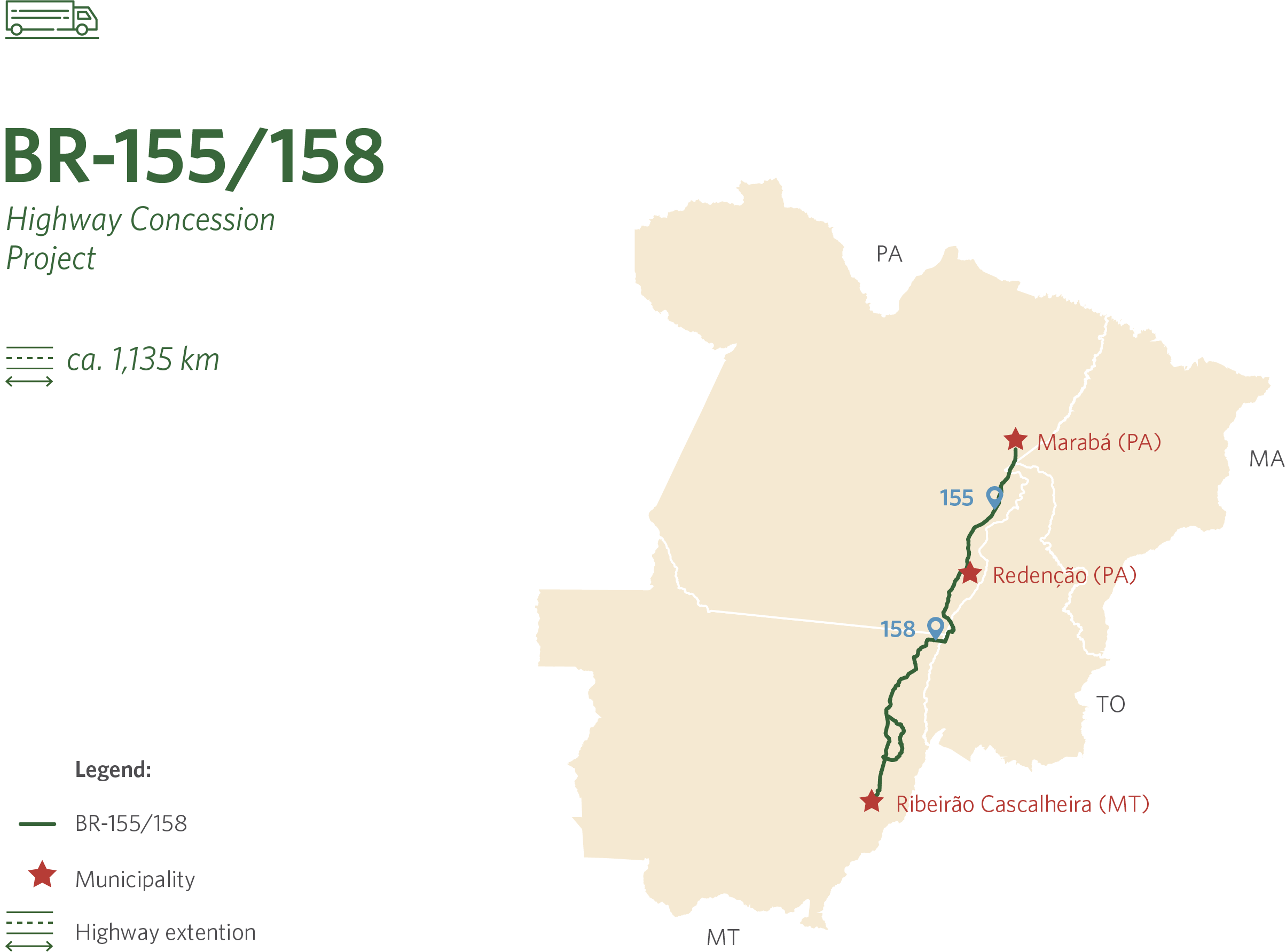
BR-155/158 is a road concession project of approximately 1,135 kilometers in length. The project includes the segment of highway BR-158 between the municipalities of Ribeirão Cascalheira (MT) and Redenção (PA) and the segment of BR-155 between the municipalities of Redenção (PA), and Marabá (PA). The project under consideration also includes the perimeter of the Marãiwatsédé indigenous area. To understand the governance, area of influence, and potential impacts of the BR-155/158 concession, researchers from CPI/PUC-Rio carried out an assessment of the legal, economic, and environmental aspects of the project.
Infrastructure governance and the administrative proceedings of BR-155/158
The viability phase for BR-155/158 began in 2020, when the Planning and Logistics Company (Empresa de Planejamento e Logística – EPL) published a public notice to commission EVTEA for federal highway concessions, including highway BR-155/158. Based on the mapping of the regulation applicable to federal land infrastructure concessions, the next step is the delivery and approval of the EVTEA.
Current Status of the Progress and Available Documents of BR-155/158
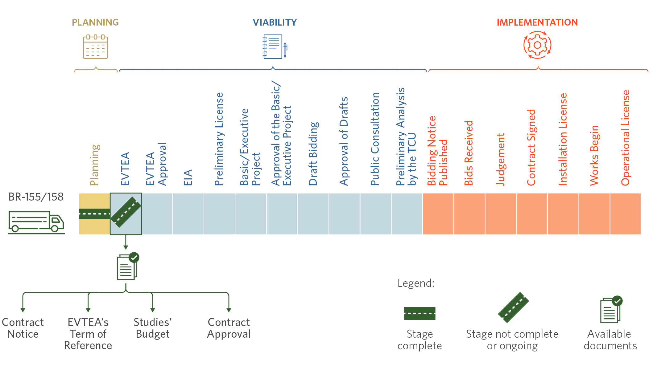
It should be noted that information on existing documents is not available on government websites, particularly those of the PPI, EPL, and the National Land Transport Agency (Agência Nacional de Transportes Terrestres – ANTT). The only information available relates to the progress made in the project – i.e., that is in the study phase. As such, researchers from CPI/PUC-Rio resorted to the Information Access Law (Lei de Acesso à Informação – LAI) to request access to documents for the preparation of the studies; only then was CPI/PUC-Rio granted access to the documents.
The key findings of the EVTEA TR analysis indicate that: (i) the EVTEA TR for BR-155/158 followed approximately 83% of what is set out in the DNIT manual; and (ii) of the ten main components listed in international guidelines, only one was not provided for in the EVTEA TR for BR-155/158.
Most Relevant Social and Environmental Components in the BR-155/158 EVTEA
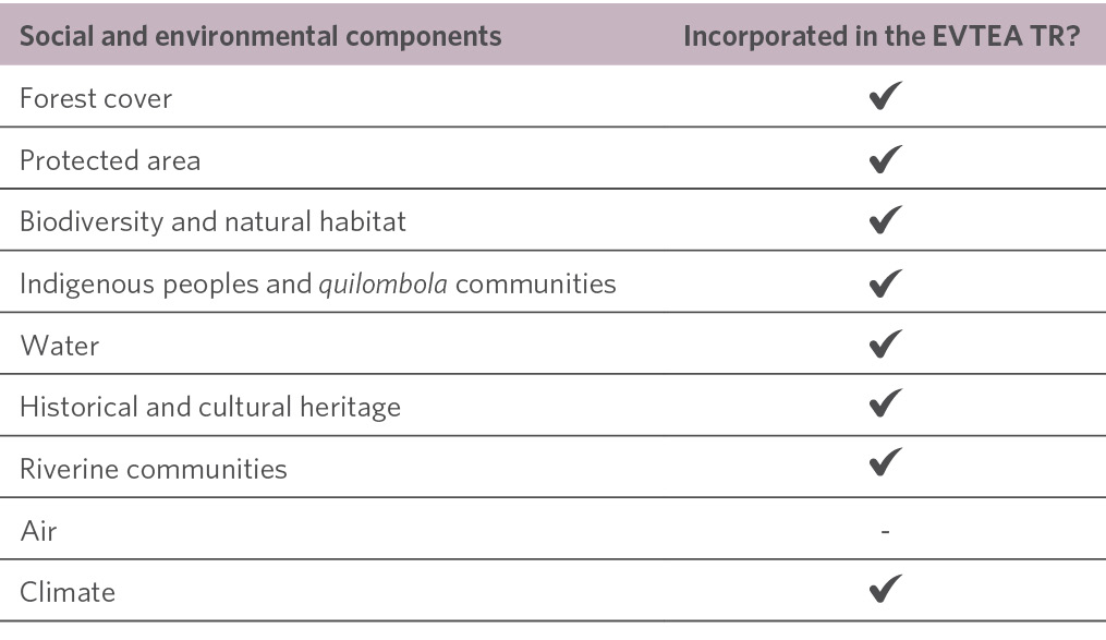
According to the quantitative analysis carried out for the EVTEA TR, it is clear that BR-155/158 shows relatively better numbers than other highways analyzed by CPI/PUC-Rio. The rate of compliance with the DNIT manual for BR-155/158 is the highest (83%) among all the projects under analysis (an average of 54%).[10] Regarding the most relevant socio-environmental components, the EVTEA TR for BR-155/158 was the only one to consider the “riverine communities” component.[11]
Such findings, however, are not definitive. BR-155/158 is still in its initial phase; the EVTEA is still being prepared and the environmental licensing process has not yet started. As such, it is not yet possible to determine whether the EVTEA TR will actually be fulfilled and whether it will be a good quality study; which components will actually be analyzed under the scope of the Environmental Impact Studies (Estudos de Impacto Ambiental – EIA) is also unknown.
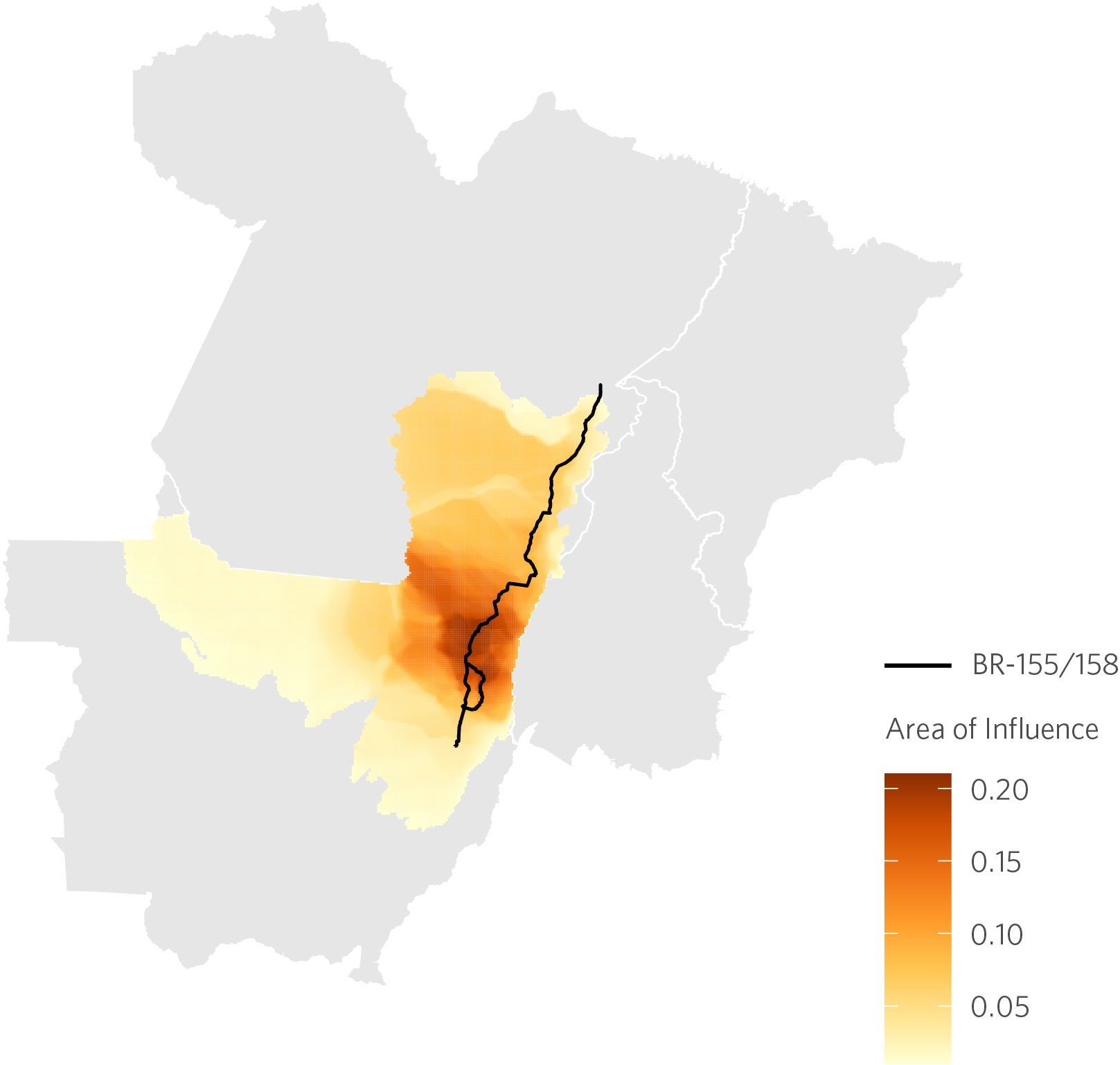
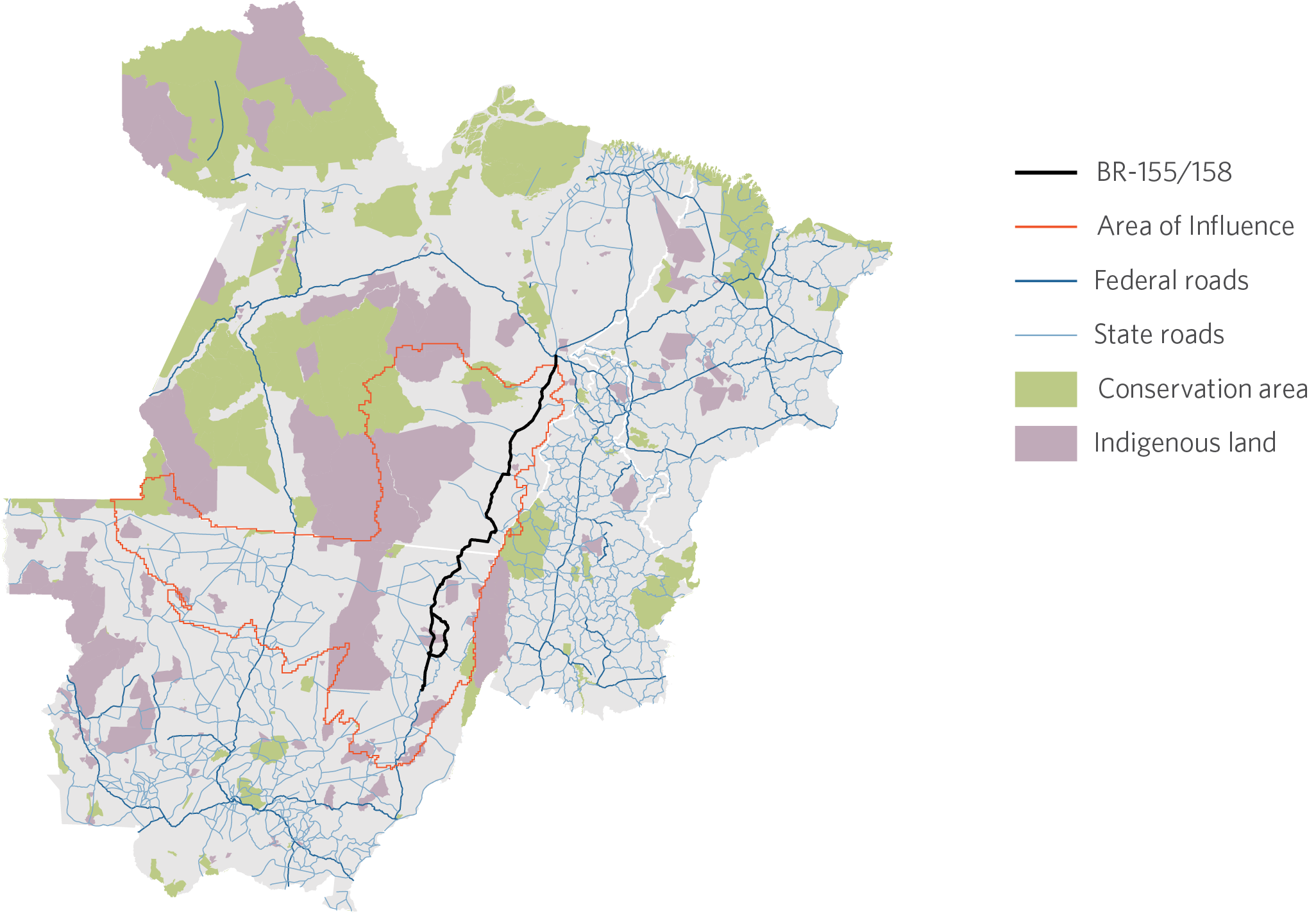
Area of Influence of BR-155/158
The area of influence of the BR-155/158 concession is delimited using the market access approach developed by CPI/PUC-Rio. This approach calculates how the levels of accessibility for different regions are affected by the reduction in transport costs caused by the concession and the resulting improvement in traffic conditions on the highway. According to this analysis, the BR-155/158 concession will significantly increase the accessibility of 69 municipalities in the states of Pará, Mato Grosso, and Tocantins. The total area of influence corresponds to almost 500,000 square kilometers. The average increase in accessibility in this area is 5.6%. The impact is concentrated around the state highways that connect to BR-155/158.
Area of Influence of BR-155/158
Risk of Deforestation
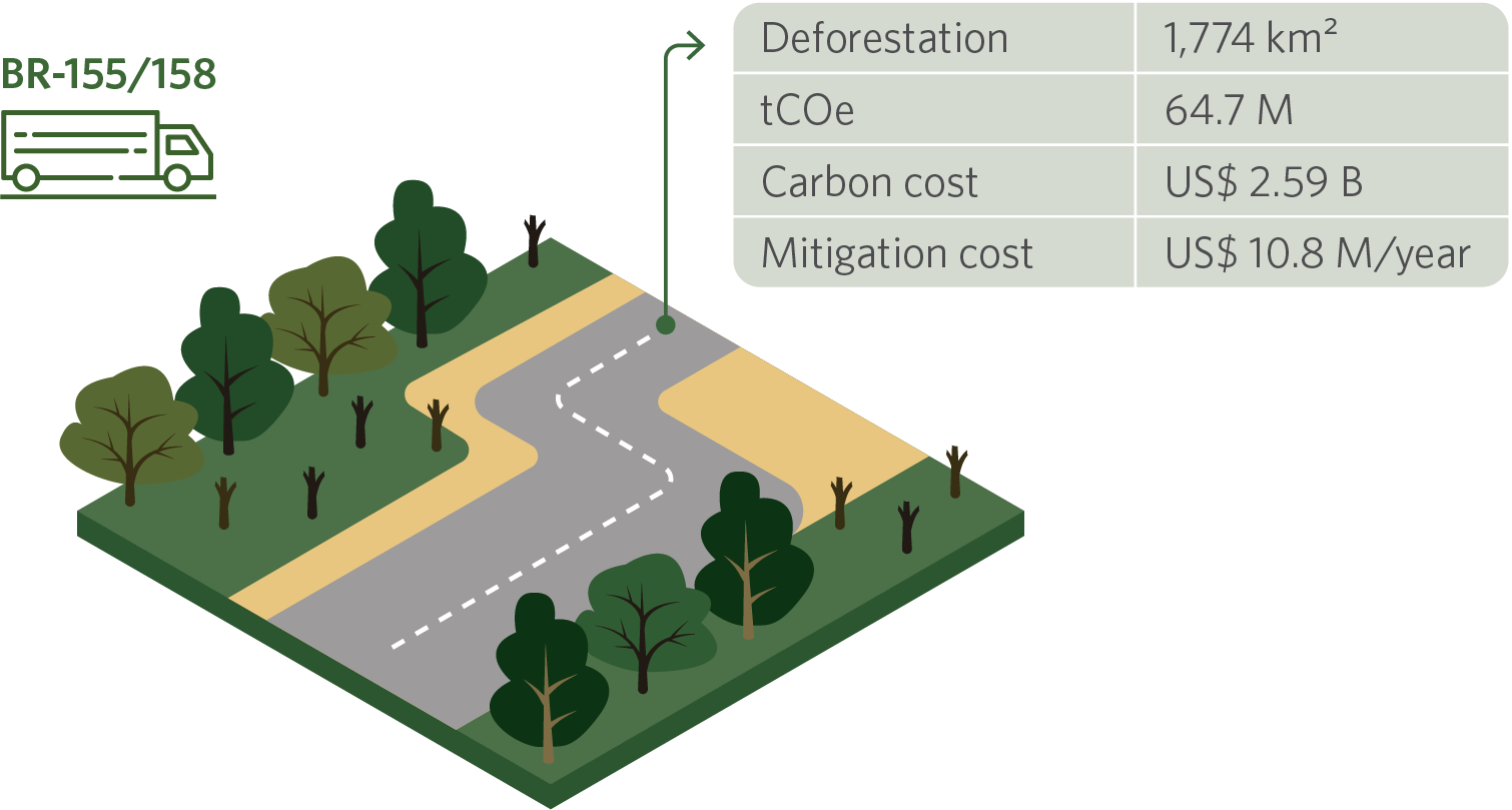
The risk of deforestation caused by the BR-155/158 concession can be computed based on statistical models tying accessibility gains to loss of forest cover. Considering the average rate of deforestation over the last decade, the result is a loss of 1,774 square kilometers in 30 years (1,383 square kilometers in the state of Pará). Using the carbon social cost used by multilateral organizations (US$ 40/tCOe) as a benchmark, this amounts to a carbon loss of around US$ 2.6 billion. According to the literature, however, these effects can be mitigated at a much lower cost. The Amazon Fund, for example, remunerates emission mitigation projects at a rate of US$ 5/tCOe. At this price point, the negative impacts of the BR-155/158 concession could be mitigated at an annual cost of US$ 10.8 million (US$ 8.5 million annually in the state of Pará). Estimates show that command and control policies may be able control deforestation at an even lower cost. As such, the inclusion of funding for mitigating and combating deforestation into the concession design can be a cost-effective way to mitigate its adverse impacts on forest cover.
OPPORTUNITIES FOR ACTION BY THE GOVERNMENT OF THE STATE OF PARÁ
Considering that the project is still in its initial phase, this is an opportunity for the state of Pará to closely monitor the progress of the project and the impacts identified in the EVTEA and voice the demands of the state as the Federal Government moves forward with the project.
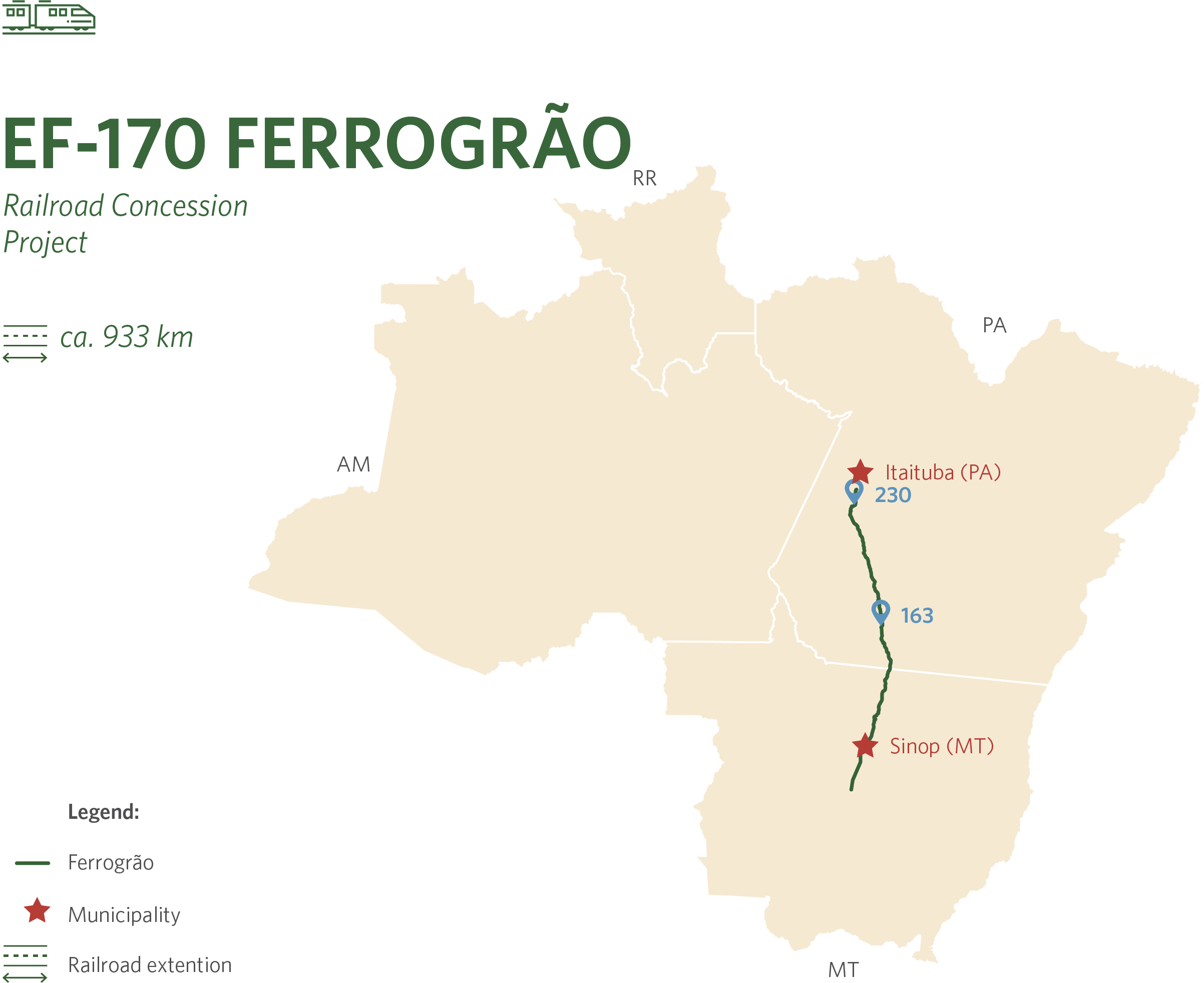
EF-170 Ferrogrão is a railroad project of approximately 933 kilometers in length. The railway will connect the municipality of Sinop (MT) to the river port complex located in the district of Miritituba, in the municipality of Itaituba (PA). To understand the governance, area of influence and potential impacts of Ferrogrão, researchers from CPI/PUC-Rio carried out an assessment of the legal, economic, and environmental aspects of the project.
Infrastructure governance and the administrative proceedings of Ferrogrão
In 2014, the Ministry of Infrastructure – then called the Ministry of Transport – formally began work on the Ferrogrão project.[12],[13],[14] Based on the analysis of the regulations applicable to federal land infrastructure concessions, the next step, if the courts allow the project to continue, is the approval of the feasibility studies and the draft notice and concession contract by the TCU. In parallel to the public hearings, in 2019 EPL published a public notice for the preparation of an EIA. The EIA was prepared by the company MRS Ambiental under the supervision of EPL and delivered to the Brazilian Institute of the Environment (IBAMA) in December 2020.[15]
Current Status of the Progress and Available Documents of Ferrogrão
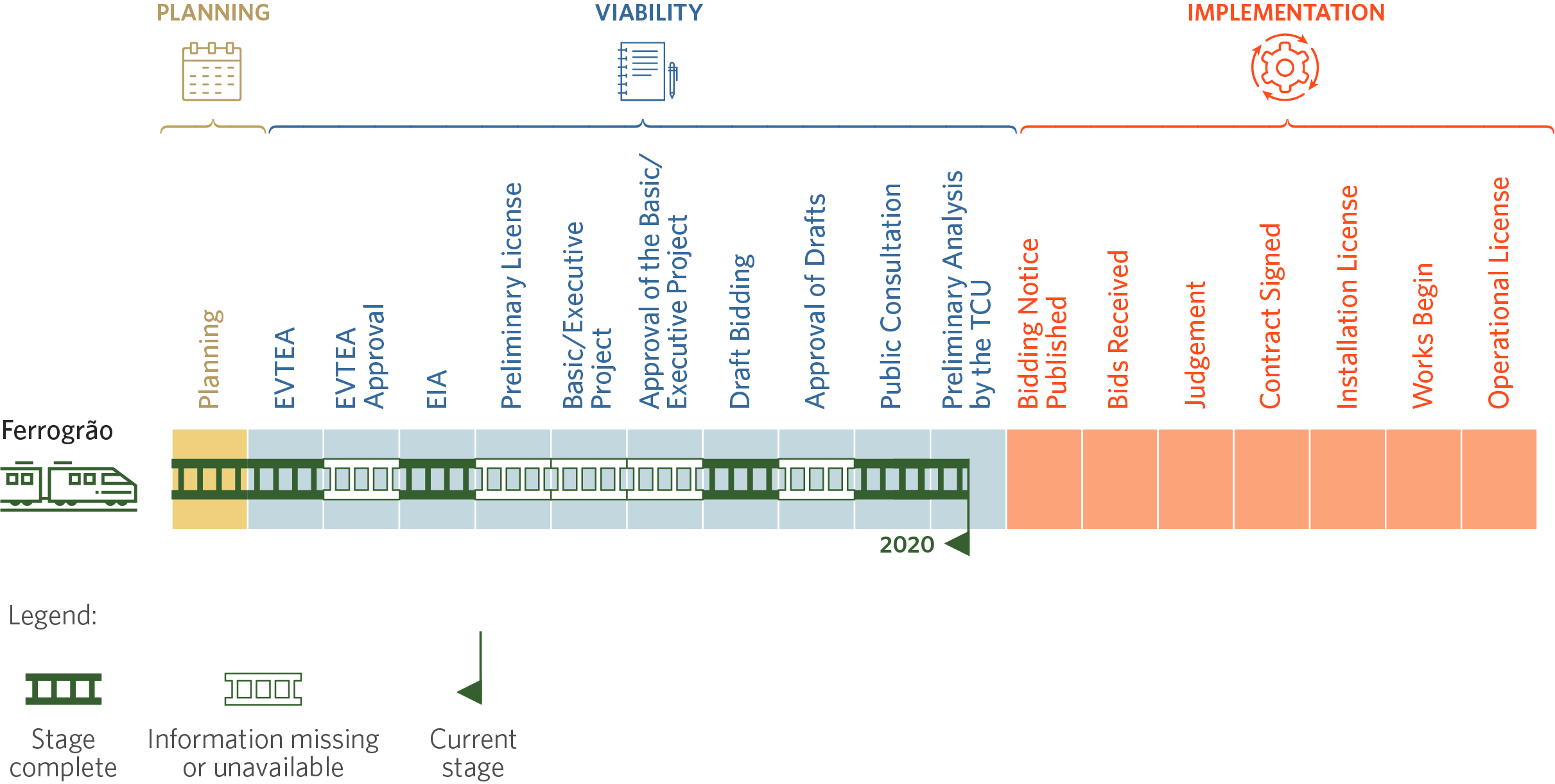
The evolution of Ferrogrão’s planning process did not exactly follow the phases depicted in the flowchart, which was also the case in other federal railway concessions analyzed by CPI/PUC-Rio.[16] This does not necessarily constitute a normative infraction, because the applicable norms do not establish a chronological order for the different phases. However, the ordering in the flowchart follows a logical precedence criterion, for example, between EVTEA and EIA,[17] which highlights the need for more clarity through the institution of formal procedures in the decision-making process. On the other hand, CPI/PUC-Rio did not have access to certain documents and information, which were neither found on the Internet nor made available through LAI.
The key findings of the EVTEA analysis are: (i) Ferrogrão’s EVTEA fulfilled 75% of its TR and looked into six components that had not been included in the TR; (ii) Ferrogrão’s EVTEA TR followed approximately 74% of what is set out in Valec’s manual; (iii) Ferrogrão’s EVTEA followed approximately 63% of what is set out in Valec’s manual; and (iv) of the ten main components listed in international guidelines, only three were included in Ferrogrão’s EVTEA TR.[18]
Most Relevant Socio-environmental Components of the TR for EVTEA and EIA in the Ferrogrão Project
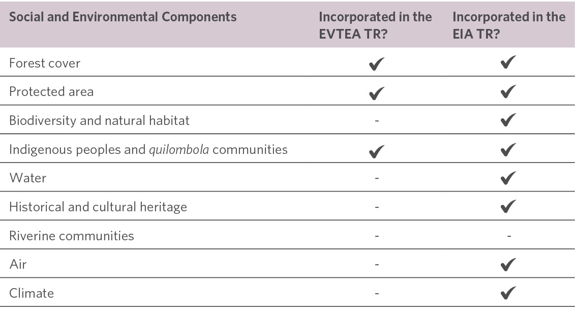
Though the EIA has not yet been approved by IBAMA, it is already available to civil society for review. The information currently available shows: (i) compliance with 91% of the EIA TR and; (ii) of the ten main components listed in international guidelines, only one – the component on riverine communities – was not provided for Ferrogrão’s EIA TR. Regarding this aspect, it should be noted that most of the TRs under analysis did not considered this component.[19]
The analysis concluded that both the EVTEA TR and Ferrogrão’s EVTEA itself failed to predict and analyze the social and environmental components most relevant to verifying the project’s potential social and environmental impacts. Also of note was the project’s weak commitment to the EVTEA preparation manual, which, though not mandatory, is a government-issued guide that should be followed more consistently, as it has been prepared by institutions working in the sector. Ferrogrão’s EIA, on the other hand, seems to be headed towards fulfilling its TR, and seems to be analyzing the most relevant socio-environmental components. This, however, does not rule out questioning the merits of the analysis, nor does it rule out a discussion about the suitability of the components provided for in the EIA TR.
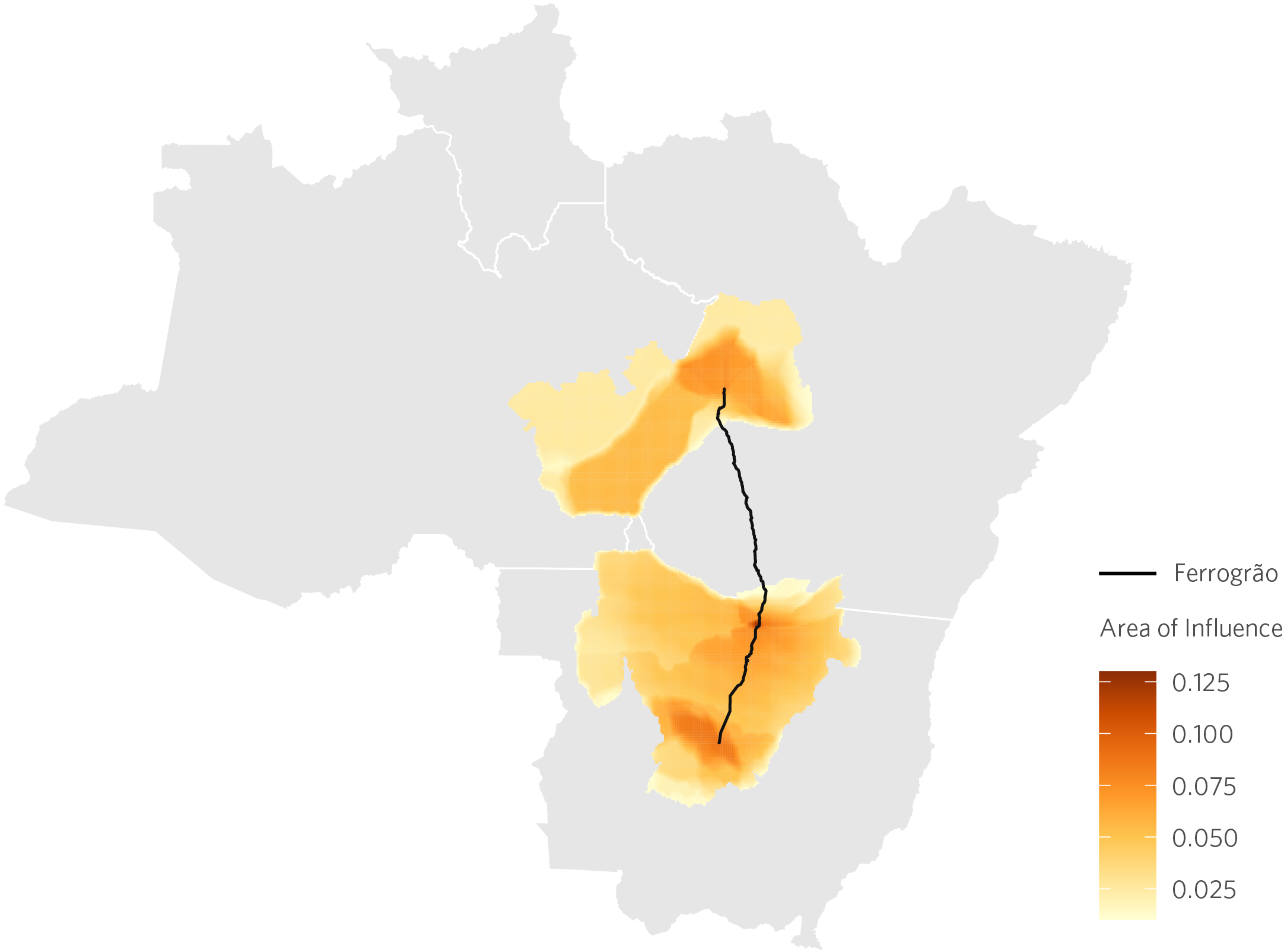
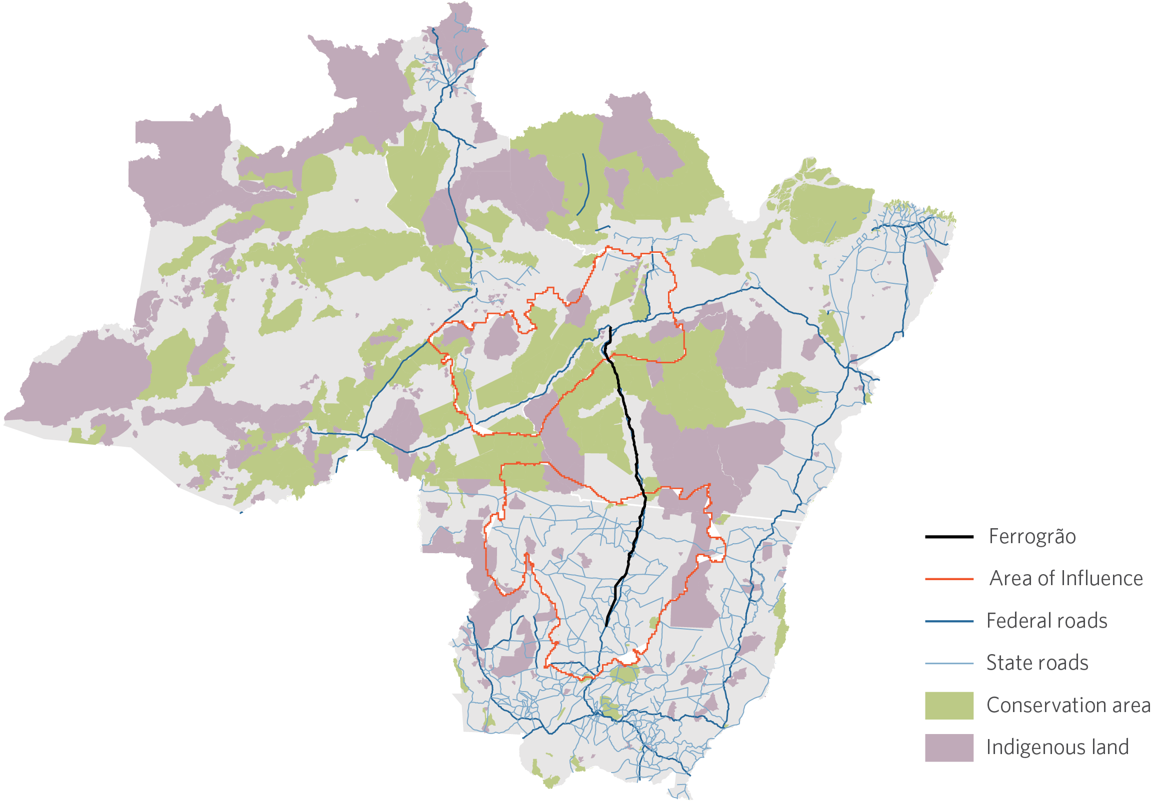
Ferrogrão’s Area of Influence
Ferrogrão’s area of influence is delimited using the market access approach developed by CPI/PUC-Rio researchers. This approach calculates how the levels of accessibility for different regions are affected by the reduction in transport costs caused by the concession and the resulting improvement in traffic conditions on the highway. According to this analysis, the construction of Ferrogrão will significantly increase the accessibility of 64 municipalities in the states of Pará, Mato Grosso, and Amazonas.[20] The total area of influence corresponds to almost 498,000 square kilometers. The average increase in accessibility in this area is 4.4%. This impact is concentrated in two regions: in the north of the state of Mato Grosso and along highway BR-230 in the states of Pará and Amazonas. There is no impact in southwest Pará because there are no stations in this region.
Area of Influence of Ferrogrão
Risk of Deforestation
The risk of deforestation caused by the construction of Ferrogrão can be computed based on statistical models tying accessibility gains to loss of forest cover. Considering the average rate of deforestation over the last decade, the result is a loss of 1,273 square kilometers in 30 years (254 square kilometers in the state of Pará).[21] Using the carbon value used by multilateral organizations (US$ 40/tCOe) as a benchmark, this amounts to a carbon loss of around US$ 1.86 billion. According to literature, however, these effects can be mitigated at a much lower cost. The Amazon Fund, for example, remunerates emission mitigation projects at a rate of US$ 5/tCOe. At this price point, the negative impacts of construction could be mitigated at an annual cost of US$ 7.74 million (US$ 1.55 million annually in the state of Pará). Estimates show that command and control policies can control deforestation at an even lower cost. As such, the inclusion of funding for mitigating and combating deforestation into the concession design can be a cost-effective way to mitigate its adverse impacts on forest cover.
OPPORTUNITIES FOR ACTION BY THE GOVERNMENT OF THE STATE OF PARÁ
Ferrogrão’s administrative proceeding is currently suspended due to judicial decision that is ruling on the dimension of Jamanxim National Park, which may affect the project’s design. Before suspended, Ferrogrão feasibility analysis was being done by TCU. However, even then, the Prosecutor’s Office within TCU (MPTCU) argued that the EVTEA should be immediately returned to ANTT given studies’ weaknesses.[22],[23] In that sense, the state of Pará could take advantage of the proceeding suspension and propose dialogues with TCU to express state’s demands that could eventually be considered in the possible project’s re-analysis by ANTT.
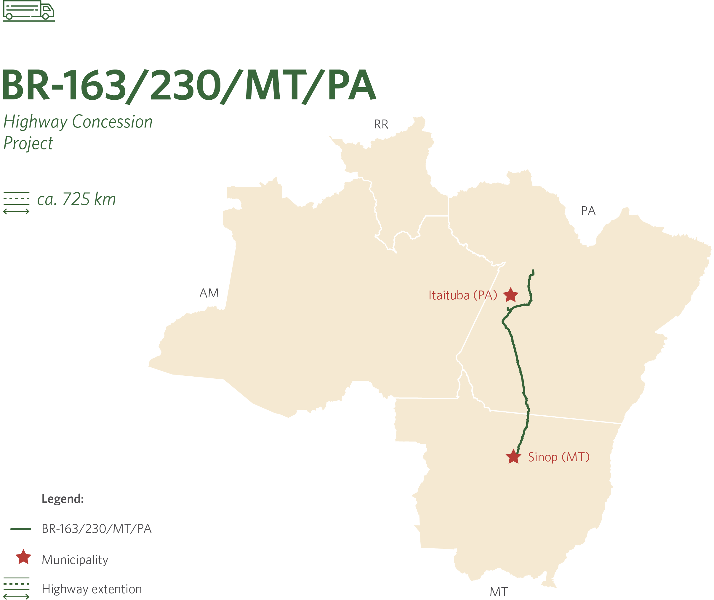
BR-163/230/MT/PA is a road concession project of approximately 725 kilometers in length. The project includes the segment of highway BR-163/230/MT/PA between the municipalities of Sinop (MT) and Itaituba (PA). To understand the governance, area of influence, and potential impacts of this concession, researchers from CPI/PUC-Rio carried out an assessment of the legal, economic, and environmental aspects of the project.
Infrastructure governance and the administrative proceedings of BR-163/230/MT/PA
The concession of BR-163/230/MT/PA underwent two stages. The first stage took place in 2015, when the Ministry of Infrastructure – then known as the Ministry of Transport – issued a public notice for the preparation of studies for the concession of BR-163/230/MT/PA for the Campo-Verde (MT)/Miritituba (PA) segment. However, after a public hearing held that same year, there was no further progress on the project.[24] In 2019, a new notice was published by the Ministry of Infrastructure, this time for the Sinop (MT)/Miritituba (PA) segment, which is currently under consideration for concession.
Based on the analysis of the regulation applicable to federal land infrastructure concessions, the project’s next step is to obtain an Installation License.[25] CPI/PUC-Rio analysts also looked into whether the environmental studies complied with the provisions in their TRs.[26] As the flowchart shows, CPI/PUC-Rio did not have access to certain documents and information, which were neither found on the Internet nor made available through the LAI.
Without information about the basic design and the progress of environmental licensing for this segment of BR-163/230/MT/PA, it is difficult to determine whether the project is following the phases depicted in the flowchart; such is also the case in other federal highway concessions analyzed in CPI/PUC-Rio’s study about federal land infrastructure concessions.[27] Failure to follow these phases does not necessarily constitute a normative infraction, because the applicable norms do not establish a chronological order. However, the ordering in the flowchart follows a logical precedence criterion, for example, between EVTEA and EIA,[28] which underscores the need for more clarity through the institution of formal procedures in the decision-making process.
Current Status of the Progress and Available Documents of BR-163/230/MT/PA
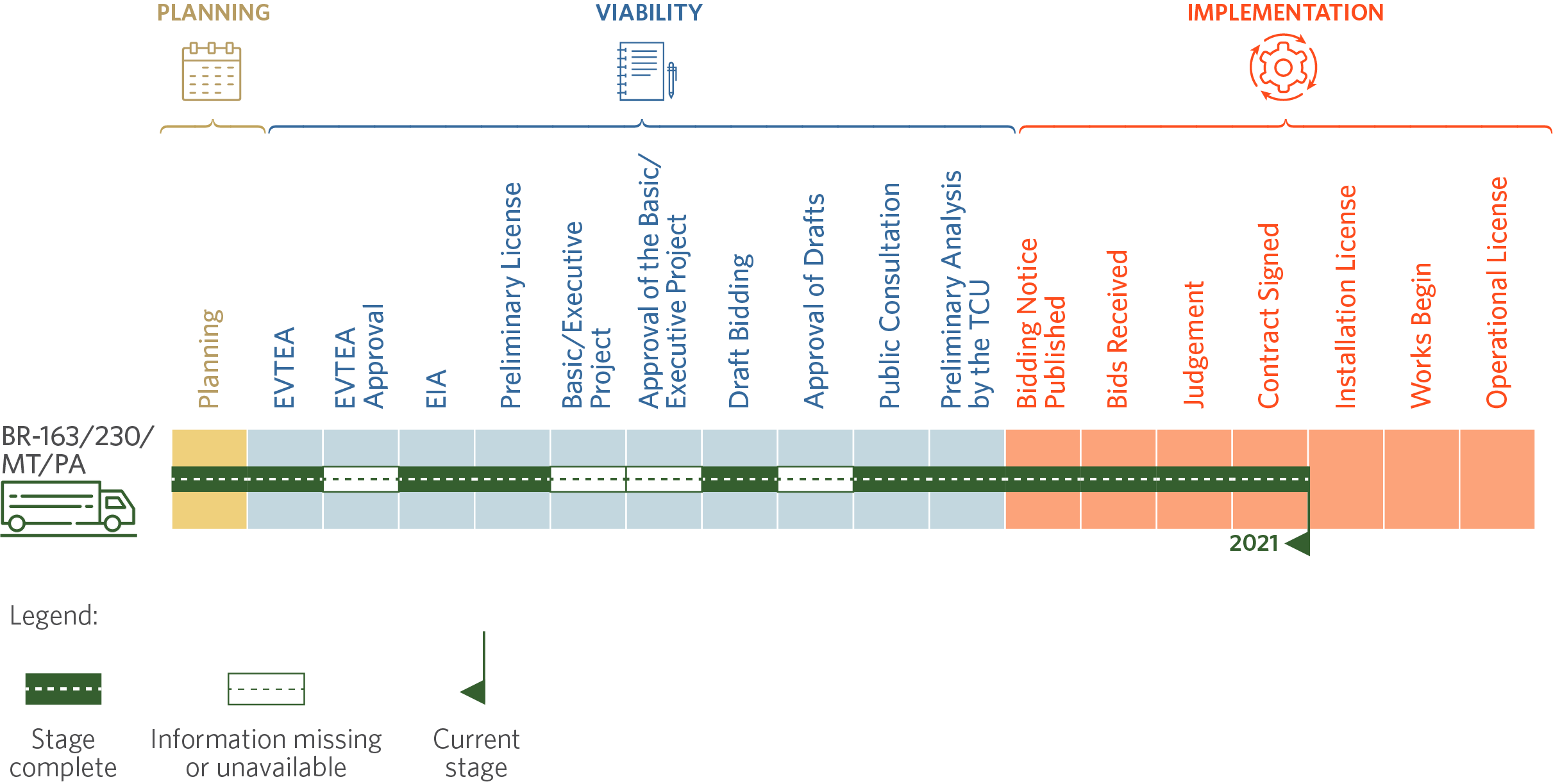
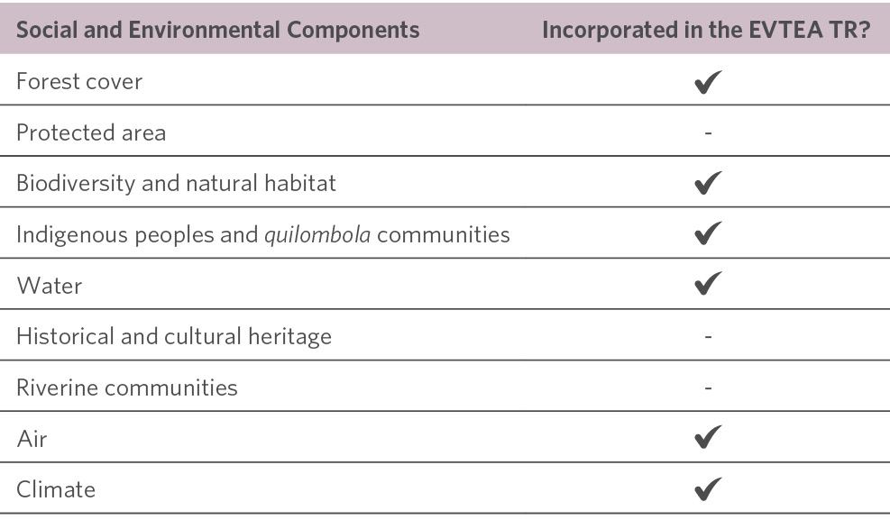
The key findings of the EVTEA analysis are: (i) The EVTEA for BR-163/230/MT/PA entirely fulfilled its TR and looked into six additional components that had not been included in the TR; (ii) the EVTEA for BR-163/230/MT/PA followed approximately 66% of what is set in the DNIT manual; and (iii) of the ten main components listed in international guidelines, seven were included in BR-163/230/MT/PA’s EVTEA TR.[29]
Most Relevant Social and Environmental Components in the BR-163/230/MT/PA’s EVTEA TR
The EIA for BR-163/230/MT/PA does not include specific information about this segment. There are, however, two terms of commitment for the environmental regulation of the highway and several other licenses for specific segments of BR-163/230/MT/PA. It should be noted that BR-163/230/MT/PA connects two extremes of Brazil, and its construction began in the 1970s, before environmental licensing was a legal requirement. Because the highway is old and paved in segments, licensing can occur in a fragmented way or through different licensing agencies, which can be at the state or federal level.[30] As such, a lack of specific licensing for the segment to be granted under concession does not necessarily imply any irregularity.
The analysis of socio-environmental studies found that the BR-163/230/MT/PA EVTEA fulfilled its TR and covered most of the most relevant socio-environmental components. However, this does not rule out questioning the merits of the analysis, nor does it rule out a discussion about the suitability of the components provided for in the EVTEA TR. Additionally, in relation to environmental licensing, the existing environmental licenses for the stretches that make up the segments to be granted under concession will need to be verified.
Finally, it should be noted that the auction of BR-163/230/MT/PA was momentarily suspendedFinally, it should be noted that the auction of BR-163/230/MT/PA was momentarily suspended due to non-compliance with a court decision that provided for the approval of a Basic Indigenous Environmental Plan (Plano Básico Ambiental – Componente Indígena – PBA-CI) prior to auction.[31] The Federal Government, in turn, overturned the court decision to suspend the auction and held it on the scheduled date. The issue of the PBA-CI, however, remains under discussion and may impose a new legal setback to the concession of the highway.
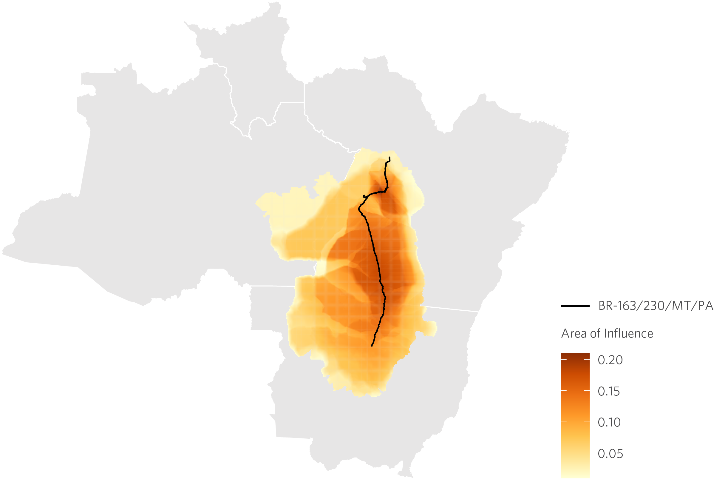
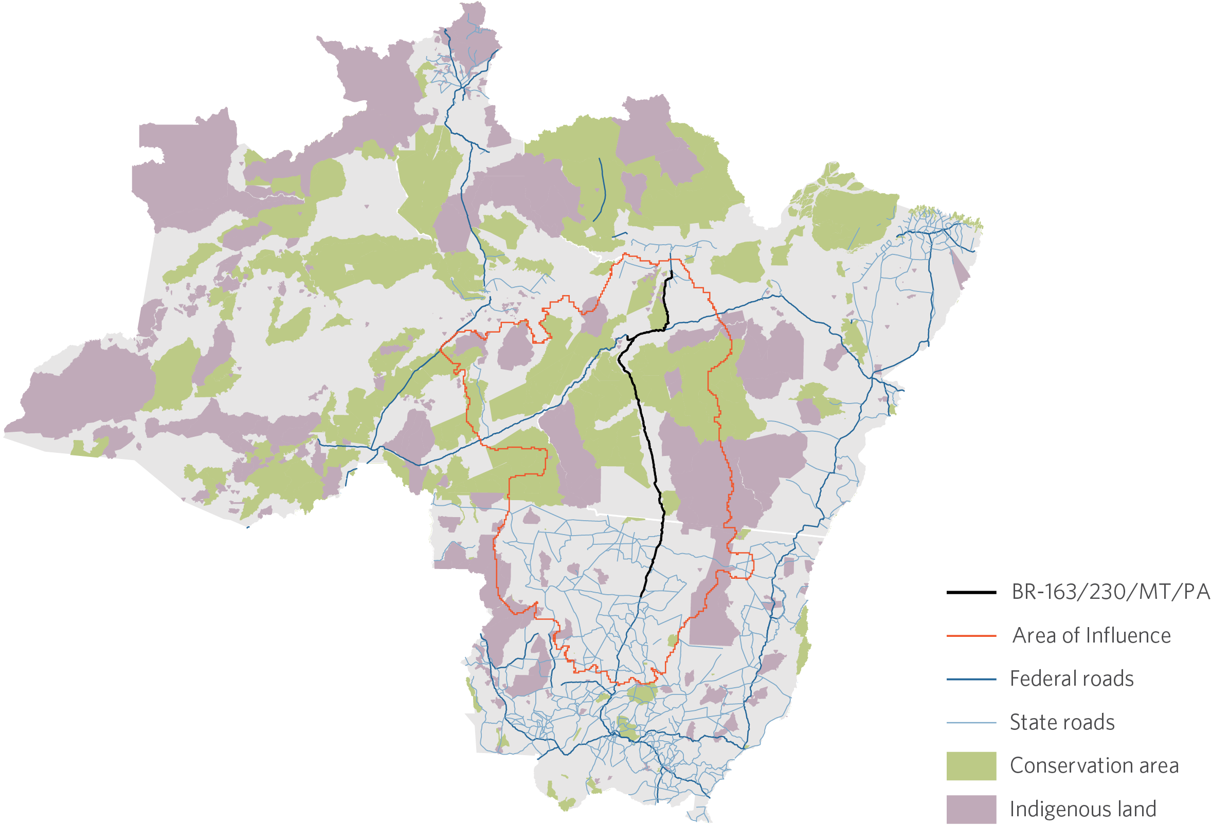
Area of Influence of BR-163/230/MT/PA
The area of influence of the BR-163/230/MT/PA concession is delimited using the market access approach developed by CPI/PUC-Rio researchers. This approach calculates how the levels of accessibility for different regions are affected by the reduction in transport costs caused by the concession and the resulting improvement in traffic conditions on the highway. According to this analysis, the concession of BR-163/230/MT/PA will significantly increase the accessibility of 61 municipalities in the states of Pará, Mato Grosso and Amazonas. The total area of influence corresponds to almost 700,000 square kilometers. The average increase in accessibility in this area is 8.8%. This impact is concentrated at the junction of highways BR-163/230/MT/PA and BR-230 and along the road in the southwest of the state of Pará. It expands throughout northern Mato Grosso and eastern Amazonas.
Area of Influence of BR-163/230/MT/PA
Risk of Deforestation
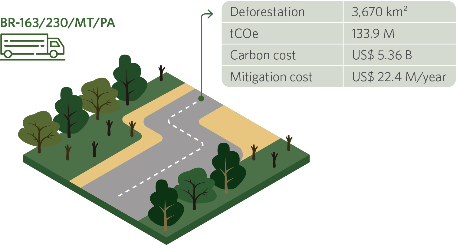
The risk of deforestation caused by the concession of BR-163/230/MT/PA can be computed based on statistical models tying accessibility The risk of deforestation caused by the concession of BR-163/230/MT/PA can be computed based on statistical models tying accessibility gains to loss of forest cover. Considering the average rate of deforestation over the last decade, the result is a loss of 3,670 square kilometers in 30 years (1,857 square kilometers in the state of Pará). Using the carbon social cost used by multilateral organizations (US$ 40/tCOe) as a benchmark, this amounts to a carbon loss of around US$ 5.36 billion. According to literature, however, these effects can be mitigated at a much lower cost. The Amazon Fund, for example, remunerates emission mitigation projects at a rate of US$ 5/tCOe. At this price point, the negative impacts of the BR-163/230/MT/PA concession could be mitigated at an annual cost of US$ 22.4 million (US$ 11.4 million annually in the state of Pará). Estimates show that command and control policies may be able control deforestation at an even lower cost. As such, the inclusion of funding for mitigating and combating deforestation into the concession design can be a cost-effective way to mitigate its adverse impacts on forest cover.
OPPORTUNITIES FOR ACTION BY THE GOVERNMENT OF THE STATE OF PARÁ
Considering that BR-163/230/MT/PA has already been auctioned off – i.e., it is currently in the implementation phase – there are no longer any suitable opportunities for the state to discuss the project itself with the Federal Government, but political coordination remains possible, as potential project impacts may happen independently of project status.
The paving of BR-230 is a 500-kilometer long public work. The project includes the completion of the paving of the BR-230 highway between Medicilândia (PA) and Campo Verde (PA). To understand the governance, area of influence, and potential impacts of these public works, researchers from CPI/PUC-Rio carried out an assessment of the legal, economic, and environmental aspects of the project.
Infrastructure governance and the administrative proceeding of BR-230
Federal highway BR-230, also known as Transamazônica, crosses the country with its four thousand kilometers of road, going from Paraíba to Amazonas and passing through Piauí, Maranhão, and Pará. The highway was created during the military government in the 1970s, at a time when there were no social and environmental obligations imposed by Brazil’s legal system.
Road paving works have been carried out by segments and, to date, have not yet covered the entire length of BR-230. The segment selected for analysis goes from Medicilândia/PA to Campo Verde/PA, the completion of which would pave the entire length of this highway between the municipalities of Marabá/PA and Itaituba/PA. No work contracts were found for the entire length of this segment. Furthermore, the paving of the segment in question was not carried out all at once. Two public notices were published in 2012 to procure paving services for three subsections, as follows:
Overview of BR-230 Subsections with Paving Notices in Effect[32],[33],[34],[35]
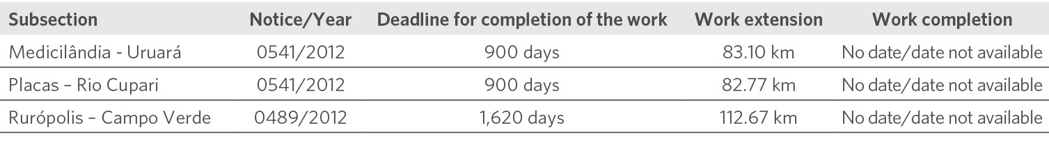
No work contract was found that included the Uruará/PA – Plates/PA subsection and the other subsections covered by the notices are not juxtaposed – i.e., they overlap in some parts, which indicates that they are not part of the same project meant to carry out progressive works on the highway. The existence of subsections included in two separate notices in the same year (Rio Cupari/PA – Rurópolis/PA) may also indicate a lack of coordinated planning and/or lack of contract execution. However, despite the dates of the notices, the website of the DNIT) shows the notices are active.[36]
It should be noted that CPI/PUC-Rio did not have access to certain documents and information, which were neither found on the Internet nor made available through the LAI.[37]
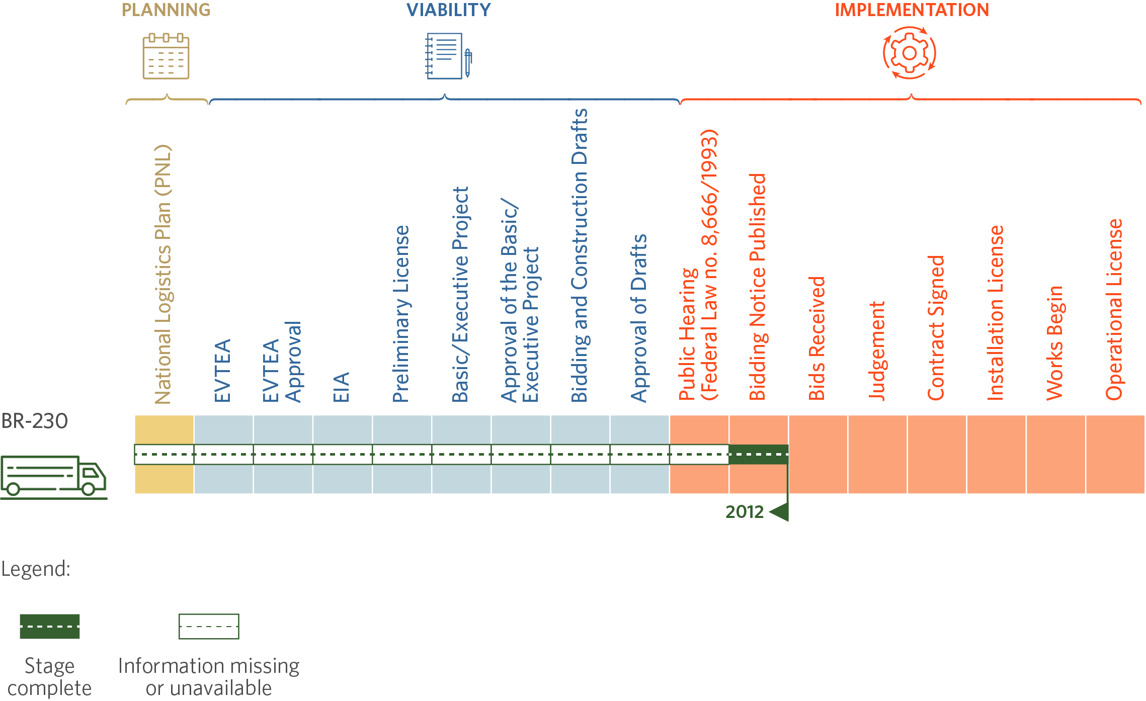
Lack of transparency hinders the monitoring of the project’s progress. CPI/PUC-Rio mapped the regulations applicable to public land infrastructure works at the federal level. Without sufficient information, it is difficult to ascertain whether the project is following the phases shown in the flowchart. This situation is not exclusive to BR-230; on the contrary, it is pervasive throughout public highway works. CPI/PUC-Rio analysts also highlighted a lack of transparency in federal highway concessions analyzed in the study on federal land infrastructure concessions.[38]
Current Status of the Progress and Available Documents of BR-230
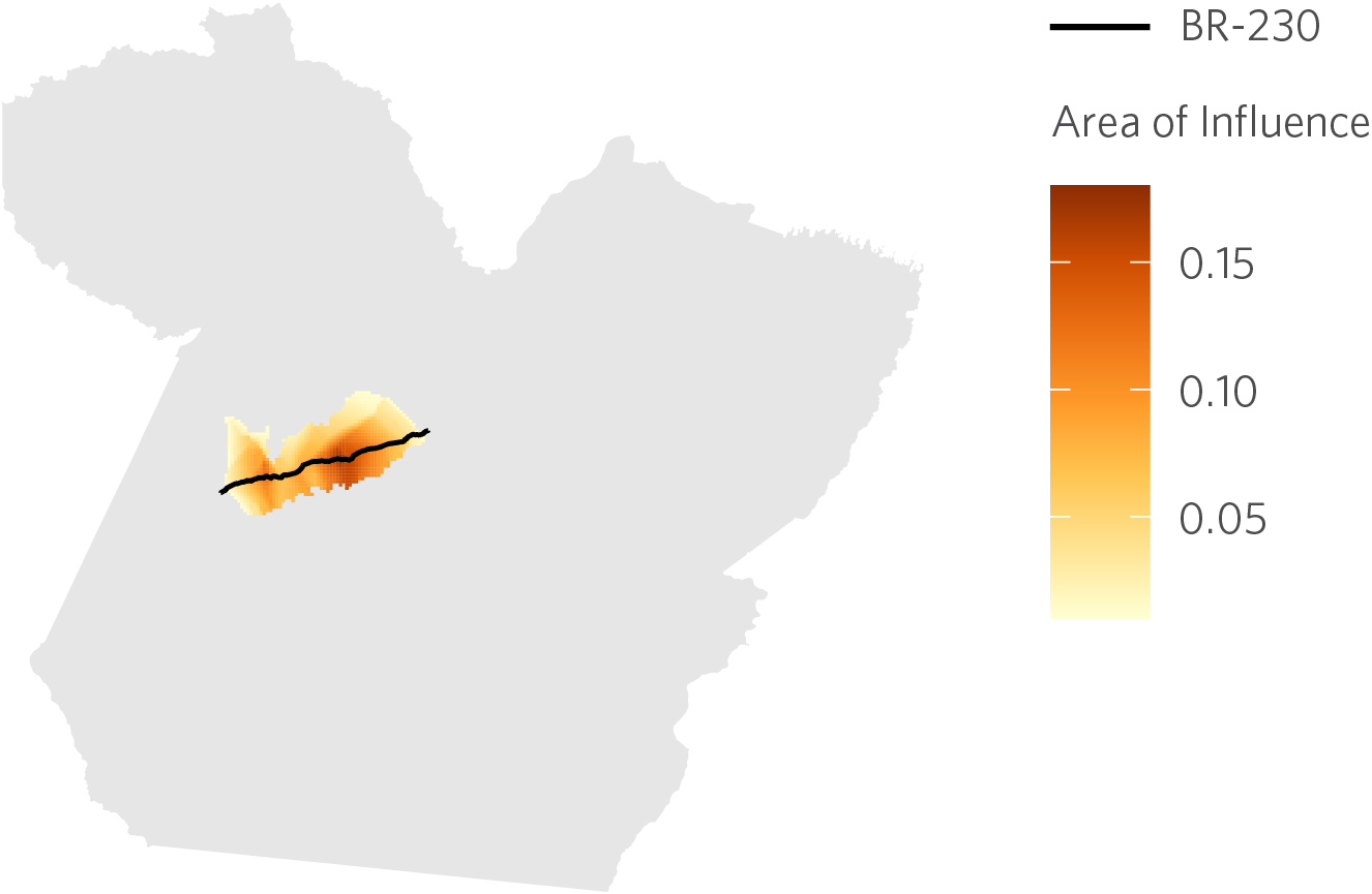
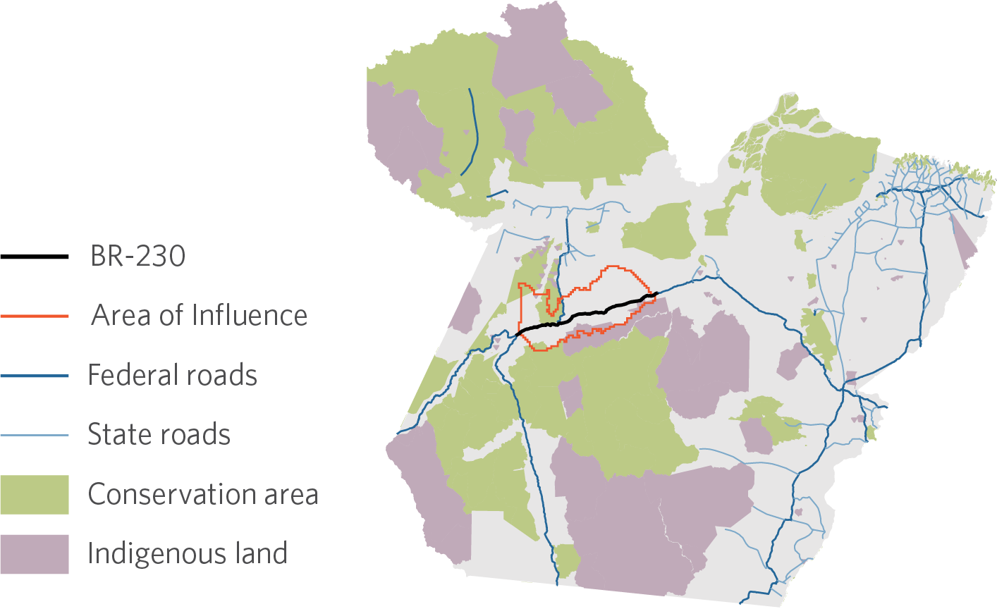
Area of Influence of BR-230
The area of influence of the project to pave BR-230 was delimited using the market access approach developed by CPI/PUC-Rio researchers. This approach calculates how the levels of accessibility for different regions are affected by the reduction in transport costs caused by the concession and the resulting improvement in traffic conditions on the highway. The analysis indicates that this public work will significantly increase the accessibility of 6 municipalities in the state of Pará. The total area of influence corresponds to almost 32,250 square kilometers. The average increase in accessibility in this area is 7.1%. This is concentrated in the segment between the municipalities of Rurópolis/PA and Placas/PA.
Area of Influence of BR-230
Risk of Deforestation
The risk of deforestation caused by the paving of BR-230 can be computed based on statistical models tying accessibility gains to loss of forest cover. Considering the average rate of deforestation over the last decade, the result is a loss of 272 square kilometers in 30 years. Using the carbon value used by multilateral organizations (US$ 40/tCOe) as a benchmark, this amounts to a carbon loss of around US$ 400 million. According to literature, however, these effects can be mitigated at a much lower cost. The Amazon Fund, for example, remunerates emission mitigation projects at a rate of US$ 5/tCOe. At this price point, the negative impacts of paving BR-230 could be mitigated at an annual cost of US$ 1.7 million. Estimates show that command and control policies may be able control deforestation at an even lower cost. As such, the inclusion of funding for mitigating and combating deforestation into the concession design can be a cost-effective way to mitigate its adverse impacts on forest cover.

OPPORTUNITIES FOR ACTION BY THE GOVERNMENT OF THE STATE OF PARÁ
Considering that the public notices are already underway (there is even a chance that they may already be concluded) the theoretical chances of a dialogue with the Federal Government before the project starts are significantly reduced. However, in practice, political coordination is still possible considering that project impacts happen independently of project status.
The authors would like to thank Gabriel Cozendey for research assistance. We would also like to thank Natalie Hoover El Rashidy and Giovanna de Miranda for the editing and revision of the text and Nina Oswald Vieira and Matheus Cannone for formatting and graphic design, Meyrele Nascimento the development of the interactive graphs, and Julia Berry for the revision of the website publications.
[1] To learn more about the work and methodology of CPI/PUC-Rio, please refer to this compilation of studies on sustainable infrastructure: Climate Policy Initiative. Sustainable Infrastructure Portfolio. 2021. bit.ly/3ERKkYr.
[2] Cozendey, Gabriel and Joana Chiavari. Environmental Viability of Land Transport Infrastructure in the Amazon. Rio de Janeiro: Climate Policy Initiative, 2021. bit.ly/3xuebBD.
[3] Infra Eco Network Europe. International Guidelines for Ecologically-adapted Linear Infrastructure. 2018.
[4] International Finance Corporation. Environmental, Health, and Safety Guidelines for Railways. 2007.
[5] International Finance Corporation. Environmental, Health, and Safety Guidelines for Toll Roads. 2007.
[6] International Road Federation. Moving Towards Green Road Infrastructure. 2013.
[7] Quintero, Juan D. A Guide to Good Practices for Environmentally Friendly Roads. Latin America Conservation Council, 2016.
[8] World Bank. Roads and the environment, a handbook. 1997.
[9] World Bank. Environmental and Social Framework. 2017.
[10] Antonaccio, Luiza and Joana Chiavari. Strengthening Environmental Studies for Federal Land Infrastructure Concessions. Rio de Janeiro: Climate Policy Initiative, 2021. bit.ly/3ichYhM.
[11] Ibidem.
[12] Deliberations 312 and 313 of July 7, 2020. bit.ly/3xM9WB6.
[13] The Floranativa Social and Environmental Institute (Instituto Sócio Ambiental Floranativa – ISAF) filed a Public Interest Civil Action (Proceeding No. 1000351-03.2020.4.01.3908/JFPA-Itaituba) to change the route of the railway and prevent it from passing through the Jamanxim Environmental Preservation Area in the state of Pará. The project documents were then sent to the Federal Court of Accounts (Tribunal de Contas da União- TCU) and a preliminary injunction was granted to that effect. However, the national land transport authority (Agência Nacional de Transportes Terrestres – ANTT) challenged this decision in Court (Interlocutory Appeal No. 1018811-25.20200.4.01.0000/TRF-1) and the Court allowed the project to move forward. It should be noted that the decision in the injunction is preliminary, and the court case is still pending.
[14] A Direct Action for the Declaration of Unconstitutionality (Ação Direta de Inconstitucionalidade- ADI) with a request for a provisional remedy was filed by the Sustainability Network Party due to the conversion of Provisional Presidential Decree 758/2016, which changed the boundaries of Jamanxin National Park. In March 2021, Supreme Court Justice Alexandre de Moraes granted a preliminary injunction suspending Law 13.452/2017 and the Ferrogrão process, whose path would pass through the area that had been reduced by the Law about the Jamanxim National Park and against which the ADI had been filed. See: Federal Court of Justice. ADI 6553. bit.ly/2Uoim47.
[15] Available at: bit.ly/37OiPiY.
[16] Cozendey, Gabriel and Joana Chiavari. Environmental Viability of Land Transport Infrastructure in the Amazon. Rio de Janeiro: Climate Policy Initiative, 2021. bit.ly/3xuebBD.
[17] As the EVTEA is a broader study meant to attest the technical, economic and environmental feasibility of a given project, it makes logical sense that it be carried out before the EIA, a restricted study that aims to identify potential social and environmental impacts that the project may generate. See: Cozendey, Gabriel and Joana Chiavari. Viabilidade Ambiental de Infraestruturas de Transportes Terrestres na Amazônia. Rio de Janeiro: Climate Policy Initiative, 2021. bit.ly/2VSbDQL.
[18] Antonaccio, Luiza and Joana Chiavari. Strengthening Environmental Studies for Federal Land Infrastructure Concessions. Rio de Janeiro: Climate Policy Initiative, 2021. bit.ly/3ichYhM.
[19] Ibidem.
[20] Previous analysis by CPI/PUC-Rio researchers, published in bit.ly/2X8S9Y4, indicated that the construction of Ferrogrão would affect 34 municipalities in the state of Mato Grosso. The analysis published here indicates a larger area of influence because researchers refined the transport model to allow the construction of railways to influence not only the cost of transporting goods from each location in the country to the port, but also the cost of transporting goods between locations in the country.
[21] Previous analysis by the CPI/PUC-Rio, published in bit.ly/2X8S9Y4, indicated that the construction of Ferrogrão would put at risk around 2,000 km2 of native vegetation. The difference between these numbers and the numbers published here reflects 4 differences in the models used: (1) the unit of analysis: this report predicts deforestation at a 5km x 5km resolution and the previous one at a municipal resolution; (2) transport model: this report considers that the construction of Ferrogrão changes the cost of transport between all locations, while the previous report only considered its effect on the transport cost to the nearest port; (3) econometric model: this report uses a dynamic model to connect market access and deforestation while the previous one uses a static model; (4) deforestation scenario: this report assumes that future deforestation will remain at the level observed in the last decade while the previous one assumed that deforestation would remain at the historical level. The deforestation scenario is the main responsible for the difference in the two numbers. Assuming that deforestation in the next 30 years will remain at the level observed in the last 30 years implies a risk of deforestation associated with the construction of Ferrogrão of 2,647 km2 (2,292 km2 in the state of Mato Grosso).
[22] Daniel Rittner. Ferrogrão enfrenta novo obstáculo no TCU. Valor, April 14, 2021. glo.bo/3CRJtpo.
[23] The draft concession contract – made available at a public hearing and submitted to the TCU – states that the concessionaire is responsible for obtaining the LP (clause 8.1.1) (National Land Transport Agency. Public Hearing No. 14/2017. bit.ly/2Ul6obi.
[24] The public hearing was reopened in 2016 with improvements to the project, presenting the Sinop-Miritituba section for a period of 12 years. Once again, however, no progress was made.
[25] Available at: bit.ly/3m7SWTz. Date of access: May 5, 2021.
[26] Antonaccio, Luiza and Joana Chiavari. Strengthening Environmental Studies for Federal Land Infrastructure Concessions. Rio de Janeiro: Climate Policy Initiative, 2021. bit.ly/3ichYhM.
[27] Cozendey, Gabriel and Joana Chiavari. Environmental Viability of Land Transport Infrastructure in the Amazon. Rio de Janeiro: Climate Policy Initiative, 2021. bit.ly/3xuebBD.
[28] As the EVTEA is a broader study meant to attest the technical, economic, and environmental feasibility of a given project, it makes logical sense that it be carried out before the EIA, a restricted study that aims to identify potential social and environmental impacts that the project may cause.
[29] Antonaccio, Luiza and Joana Chiavari. Strengthening Environmental Studies for Federal Land Infrastructure Concessions. Rio de Janeiro: Climate Policy Initiative, 2021. bit.ly/3ichYhM.
[30] Casa Civil (Presidential Staff Office). Complementary Law 140/2011. bit.ly/3k5Om5Y.
[31] Available at: bit.ly/3skG1ii. Date of access: July 8, 2021.
[32] Deadlines may have been extended by means of contract amendments.
[33] See: bit.ly/37Ro9lP. Date of access: June 1, 2021.
[34] Ibidem.
[35] See: bit.ly/2UoBe2X. Date of access: June 1, 2021.
[36] See: bit.ly/3mclgnU. Date of access: June 1, 2021.
[37] Information was requested via the LAI about the existence of an EVTEA. In response, DNIT stated: “there is no database available with information about an EVTEA (or lack thereof) for the referred contract [the Medicilância-Uruará subsection]; the contract notice was published almost 10 (ten) years ago.” There was no response regarding the completion of the works.
[38] Cozendey, Gabriel and Joana Chiavari. Environmental Viability of Land Transport Infrastructure in the Amazon. Rio de Janeiro: Climate Policy Initiative, 2021. bit.ly/3xuebBD.
