Redefining Priorities in Infrastructure Development in the Amazon: Evidence from the State of Pará
Infrastructure plans designed for the Brazilian Amazon tend to focus on large projects such as roads, hydropower plants, transmission lines, waterways, and ports, neglecting other types of local infrastructure such as sanitation services, health care and educational facilities, local roads, and information technologies that are fundamental for the quality of life of the local population. Balancing the demand for large-scale projects with the need for smaller, local infrastructure that serves citizens more directly is fundamental to promote sustainable development in the region. A proper diagnosis of what problems in access to different types of infrastructure exist across different sectors is key for shifting the focus of infrastructure plans from building infrastructure in the Amazon to building infrastructure for the people living in the Amazon.
In this project, researchers from Climate Policy Initiative/Pontifical Catholic University of Rio de Janeiro (CPI/PUC-Rio) map the quality of local infrastructure in the state of Pará, Brazil. Using high-resolution data on local infrastructure, it documents access to health and educational facilities, presence of roads, and quality of cellphone coverage in the state. This type of information is fundamental to guide discussions of priorities in infrastructure plans, public policies aimed at improving the quality of life of the people living in the Amazon, and debates on compensations paid by large projects to be built in the region.
Pará is the most populous state of the Brazilian Amazon with a population of 8.07 million. Its citizens live in an area of over 1.24 million square kilometers, resulting in a population density of 6.5 inhabitants per square kilometer, which is roughly one-fourth of the population density of the rest of the country. Moreover, the state’s population is extremely concentrated geographically: three-quarters of all its citizens live in 1% of the state’s territory. The analysis combines high-resolution data on population with the location of different types of local infrastructure to gauge the local population’s access to five types of infrastructure: sanitation services, 4G network (cellphone service), schools, health care facilities, and local and state roads. It reveals three main facts.
KEY FINDINGS
First, access to sanitation services is extremely low throughout the whole state. More than two-thirds of the state’s population disposes sewage inadequately. Furthermore, in most of the state’s territory, almost the whole population does not have access to adequate sewage services.
Second, access to internet, health care and educational facilities, and local roads is extremely unequal across the state of Pará. Outside the state capital and its surroundings, roughly one quarter of the population faces difficulties in connecting to the internet and is located far from health care and educational facilities. Access to these types of infrastructure is particularly poor small municipalities and in the western part of the state and the Marajó island.
Third, the quality of local infrastructure in surroundings of large infrastructure projects is particularly bad. Inhabitants of these regions have lower access to sanitation services, worse connectivity, and are located further from health and educational facilities than the typical inhabitant of the state. These findings illustrate the importance of redefining the priorities of infrastructure plans designed for the Brazilian Amazon. Focusing on large-scale infrastructure projects is unlikely to address needs and improve the quality of life of the local population. Therefore, it is important to mobilize resources for investing in local infrastructure alongside investments in large-scale infrastructure.
Taken together, these findings document the existence of substantial problems in the state of Pará’s local infrastructure. This reveals the importance of putting local infrastructure at the center of infrastructure plans. Ensuring proper funding for these types of projects poses a significant challenge for local, state, and federal governments. Using compensation payments from large-scale projects to fund local infrastructure might be an important avenue to better balance the demand for large-scale infrastructure with the need for smaller, local infrastructure that serves citizens more directly.
This work illustrates potential of high-resolution geo-referenced data to map disparities in access to basic services as well as to document infrastructure gaps in small geographic units in the Amazon. This type of data and analysis have several potential applications from guiding public policies to mapping local infrastructure financing gaps in the surrounding of large projects like dams, roads, and mining operations.
Access to Sanitation Services is extremely poor
Access to sanitation services is extremely poor in the state of Pará. This is true for access to the water supply and the sewage system.
Household-level data indicate that 52% of the households in the state are not connected to the water network. This is more than three times the share of households not connected to the water network in Brazil as a whole. About three-fourths of the households without adequate water supply (37% of the households in general) obtain water through wells, while the remaining one fourth (15% of the households of the state) collect water directly from rivers, rainfall, or other sources. Tract-level census data indicate poor access is coupled with appalling spatial inequalities in access to the water supply network (Figure 1). Access to the water network is more prevalent in Belém, Santarém, and in areas near these urban centers. Outside these regions, access to the water supply network is very poor. This includes relatively large municipalities such as Marabá and Altamira where, respectively, only 38.5% and 19.0% of the households have access to the water network.
The situation is even worse for sewage collection. Household-level data show 69% of the state’s households dispose sewage improperly, either in rudimentary tanks (48%) or directly dumping it in waterways (21%). Of the 31% of the households that properly dispose sewage, two-thirds use septic tanks (21% of the total) and one-third is connected to the sewage network (10% of the total). Digging deeper into the data at a more local level shows that poor access is coupled with extreme regional inequalities in adequate sewage disposal (Figure 2). Outside of the state capital of Belém, its surroundings, and some isolated localities, less than 10% of households dispose sewage adequately in 83% of the state’s census tracts.
Uma análise ao nível das localidades (setores censitários) demonstra ainda uma desigualdade extrema entre as regiões (Figura 2). Fora da região metropolitana de Belém e alguns centros urbanos isolados, serviços de coleta de esgoto são praticamente inexistentes. Menos de 10% dos domicílios coletam esgoto inadequadamente em mais de 80% das localidades do estado do Pará.
Figure 1. Water Network by Census Tract, 2021
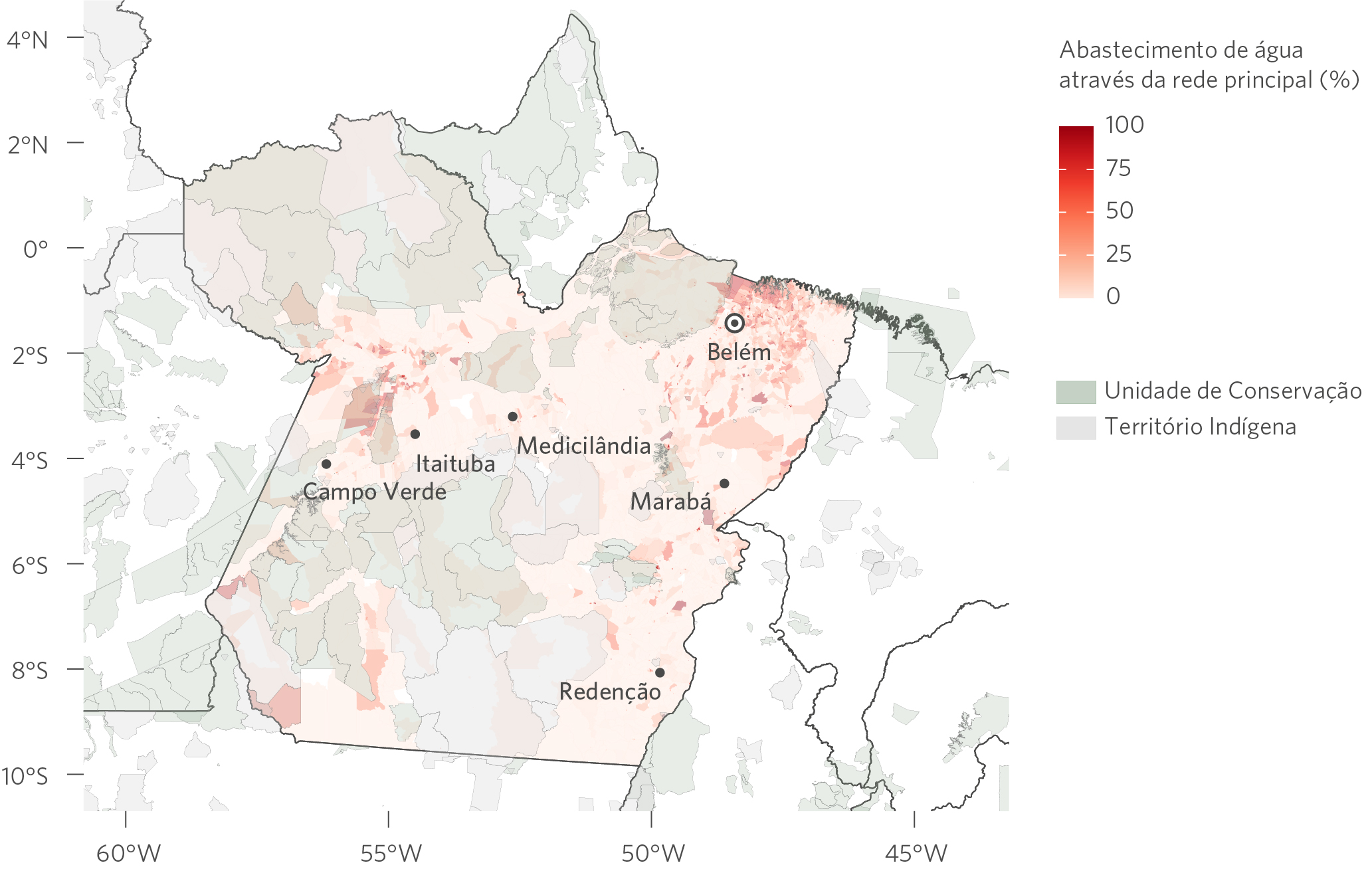
Source: CPI/PUC-Rio with data from Demographic Census (2010) at the census tract level, 2022
Figure 2. Sewage Collection by Census Tract, 2021
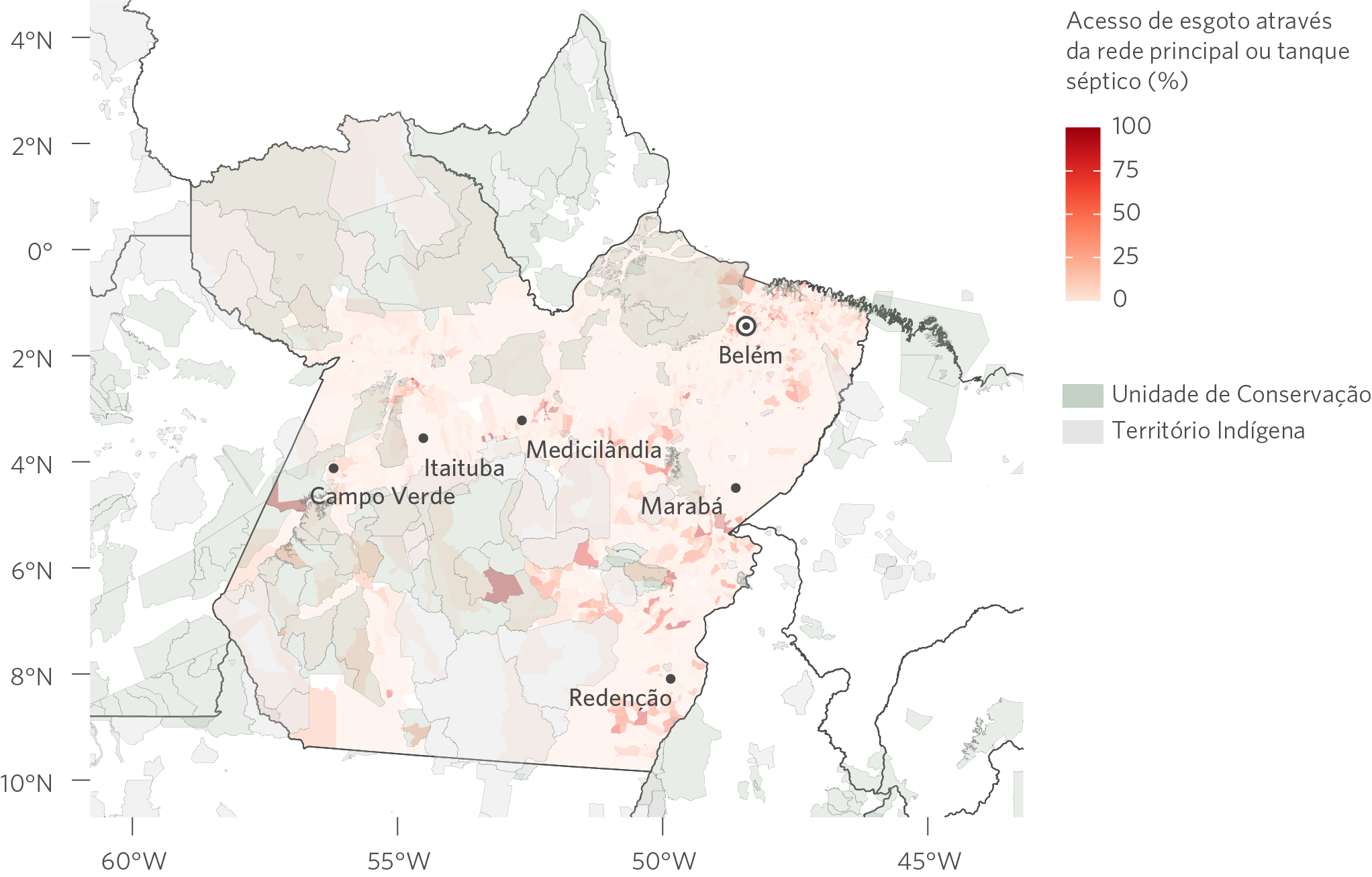
Source: CPI/PUC-Rio with data from Demographic Census (2010) at the census tract level, 2022
Disparities In Access To Most Types Of Infrastructure Is Large
Data on access to cellphone services, health and educational facilities, and roads throughout the state of Pará show substantial disparities between citizens’ access to basic infrastructure across the state. These types of infrastructure are concentrated in the most densely populated regions, leaving residents of small communities, rural areas, and indigenous lands with inadequate access to local infrastructure.
The access to 4G network (a proxy of the quality of cellphone services) is a good example of the disparities in access to basic services throughout the state of Pará. The geographic distribution of 4G antennas broadly reflects distribution of the state’s population with antennas concentrated in the more populated regions. The analysis reveals 16.9% of the population (1.36 million people) lives 10 kilometers or more from the nearest 4G antenna (Figure 3). While the exact coverage of an antenna is not fixed, it rarely exceeds ten kilometers. Thus, this figure provides a conservative estimate of the population with weak cellphone service throughout the state.
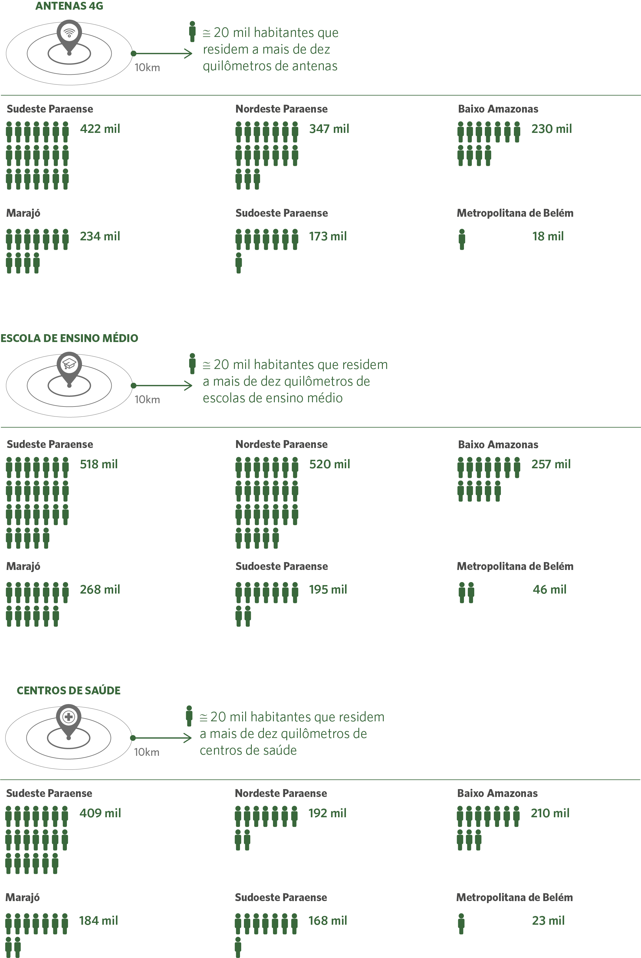
Comparable numbers are found for other types of local infrastructure. 21% of the state’s population (1.7 million people) lives more than 10 kilometers from high schools and 14% of the state’s population (1.13 million people) lives more than 10 kilometers from healthcare centers (Figure 3).
Breaking the analysis down by municipality size and region provides more evidence of the regional disparities in access to local infrastructure (Figures 3 and 4). More than 98% of the inhabitants of the metropolitan region of Belém live less than 10 kilometers from antennas, high schools, and healthcare facilities. Access to infrastructure is much worse in the rest of the state. 13% of the population in municipalities with more than 50,000 inhabitants and 20% of the population of municipalities with less than 50,000 inhabitants lives 10 kilometers of more from the antennas, high schools, and healthcare centers (Figure 4). Furthermore, more than one fifth of the population of three of the six regions of the state lives 10 kilometers of more from the antennas, high schools, and healthcare centers (Figure 5). These results show the challenges of providing infrastructure in the low-density regions of the state of Pará.
Figure 3. Distance to Local Infrastructure, 2021
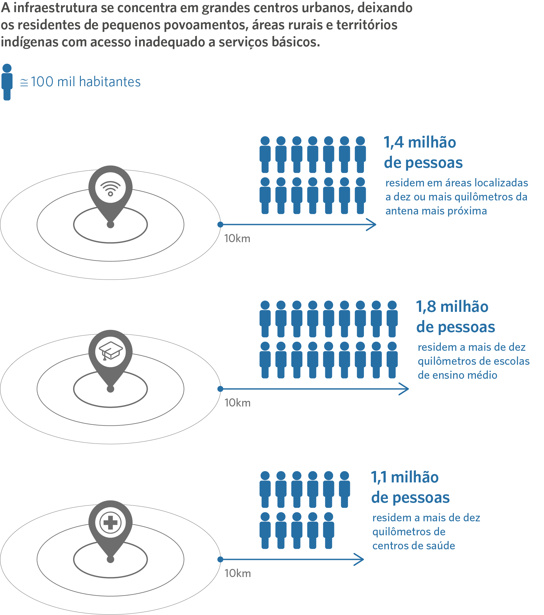
Source: CPI/PUC-Rio with data from OpenCellID (2021), the School Census (2019) and the National Register of Health Establishments (2019), 2022
Figure 4. Distance to Local Infrastructure by Municipality Size, 2021
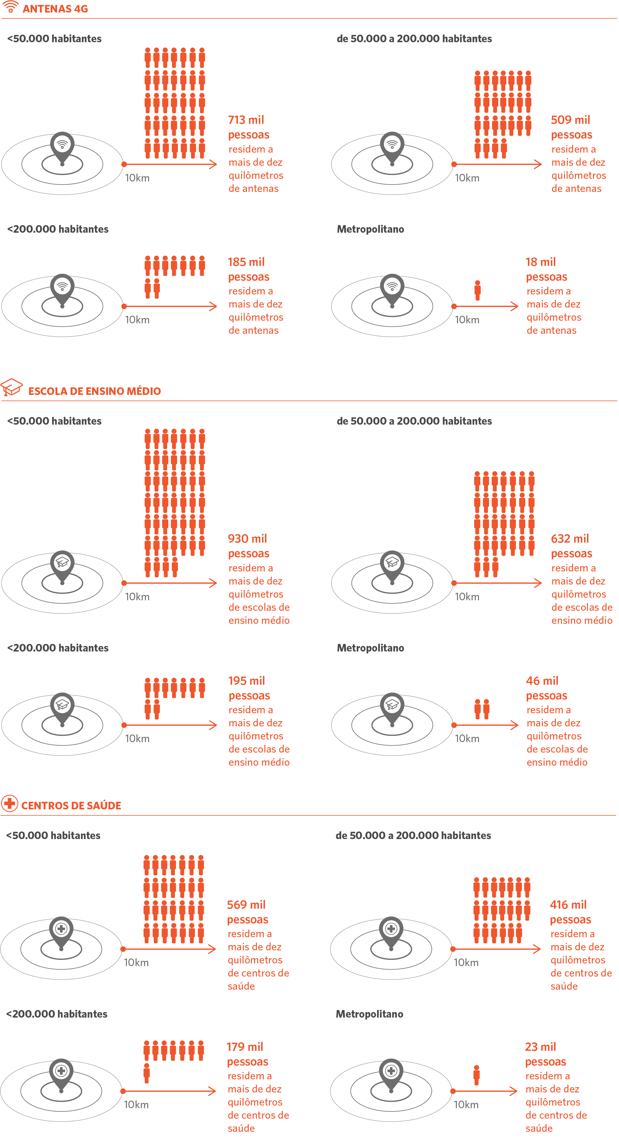
Source: CPI/PUC-Rio with data from Gridded Population of the World (2020), OpenCellID (2021), School Census (2019), and National Health Establishment Registry (2019), 2022
Figure 5. Distance to 4G Antennas by Region, 2021
Source: CPI/PUC-Rio with data from Gridded Population of the World (2020), OpenCellID (2021), School Census (2019), and National Health Establishment Registry (2019), 2022
Local Infrastructure gaps in the surroundings of large infrastructure projects are large
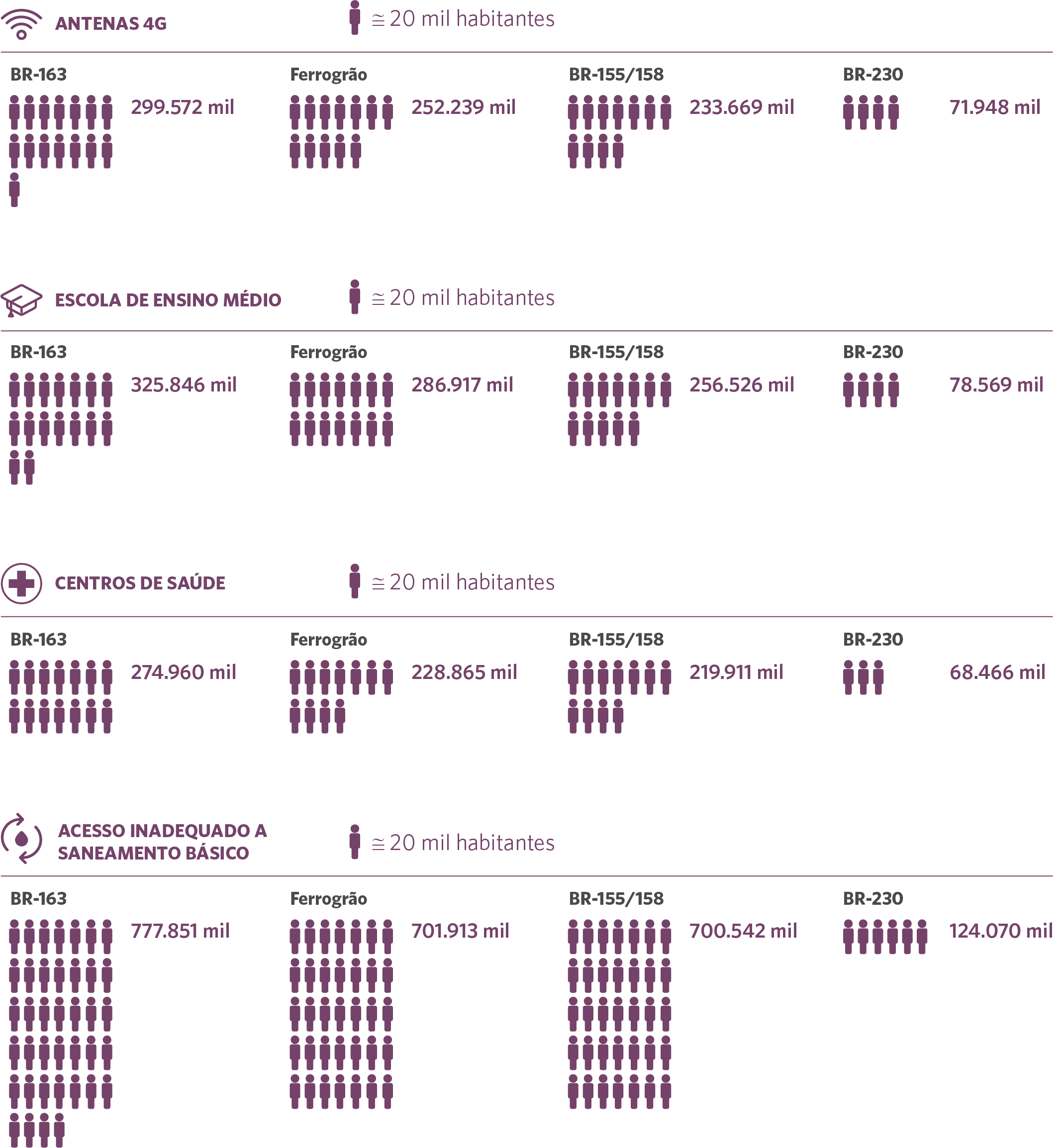
CPI researchers have mapped projected federal infrastructure investments in the state of Pará planned over the coming decade (the construction of the Ferrogrão railroad, the paving of BR-230, and improvements to BR-163 and BR-155/58). Using the market access tool developed by CPI that identifies the area of influence of these projects, researchers estimate that 1.92 million people will be affected by these projects. A total of, approximately, 1 million people will be affected by one of these projects, 830 thousand people will be affected by two of the projects, and 90 thousand people will be affected by three projects.
This population faces substantial difficulties to access local infrastructure. Despite being located closer to roads than the typical inhabitant of the state, the inhabitants of these areas of influence have worse access to sewage services, mobile internet, health facilities, and high schools than the typical inhabitant of the state (Figure 6).
The problems in access to local infrastructure are particularly striking in the area surrounding BR-230. More than 90% of the population living in the area of influence of this project does not collect sewage adequately, roughly 20 percentage points more than in the state as a whole. Furthermore, than 50% of the population of this area of influence resides more than 10 kilometers from 4G antennas, health care facilities, and high schools, compared to less than 20% in the state as a whole.
The differences in the quality of local infrastructure in the surroundings of BR-155/158, BR-163, and the Ferrogrão railroad are much smaller. Yet, access to basic services in the area of influence of these projects is worse than in the rest of the state in all considered dimensions.
Figure 6. Local Infrastructure in the Area of Influence of Large Logistics Projects, 2021
Source: CPI/PUC-Rio com base nos dados do OpenCellID (2021), do Censo Escolar (2019), Cadastro Nacional de Estabelecimentos de Saúde e Censo Demográfico (2010) ao nível de setor censitário (2019), 2022
Conclusion
These findings indicate that large-scale investments focused on upgrading roads and building railroads are being planned in regions with much more basic infrastructure demands. While it is often argued that this type of large-scale investments increases economic growth and induce improvements in local infrastructure, the experience of the Amazon in the last three decades indicates that these projects do not generate economic benefits large enough to induce substantial improvements in local infrastructure. Therefore, the evidence presented here illustrates the importance of redefining the priorities of infrastructure plans designed for the Brazilian Amazon.
Mobilizing resources to invest in local infrastructure is one key challenge for redefining priorities of infrastructure plans designed for the region. Small infrastructure focused in providing basic services for the local population is unlikely to attract private capital as large-scale infrastructure focused in providing services for exporters. Thus, increasing investments in local infrastructure typically requires increasing taxation or reallocating the government budget. These two measures are difficult to pursue in the short-term given the fiscal constraints of the country.
One possibility to overcome these constraints is to direct the compensation paid by the large projects to finance improvements in local infrastructure. The type of data presented in this report might be useful to guide discussions on the use compensation payments to finance infrastructure projects focused in providing basic services for the local population.
We thank Pietro Lucchesi for excellent research assistance. We are grateful to Juliano Assunção, Ana Cristina Barros, Joana Chiavari, Natalie Hoover El Rashidy, Giovanna Miranda, and Jennifer Roche for their comments and suggestions and to Meyrele Nascimento for their help with graphics and figures.
[1] Bragança, Arthur, Luiza Antonaccio, Brenda Prallon, Ana Cristina Barros and Joana Chiavari. Governance, Area of Influence and Environmental Risks of Transport Infrastructure Investments: Case Studies in the State of Pará. Rio de Janeiro: Climate Policy Initiative, 2021. bit.ly/3v4H9IG.
[2] A total of 971,744 people live in the area of influence of BR-163; 942,313 people in the area of influence of BR-155/158; 890,107 people in the area of influence of the Ferrogrão railroad; and 131,710 million people in the area of influence of BR-230.
