Menu

Authors: Bismart Ferry Ibie, Nina Yulianti, Nyahu Rumbang, and Evaphilo Ibie of the Palangka Raya Institute for Land Use and Agricultural Research (PILAR)

EXECUTIVE SUMMARY

Central Kalimantan is at a crucial juncture for sustainable land use. The region is in the middle of a mid-term regional development planning process and has the opportunity to make choices that benefit its communities and businesses into the future. Strong, evidence-based information on land values can inform the Strategic Environmental Assessment which feeds into the provincial spatial plan (Rencana Tata Ruang Wilayah Provinsi or “RTRWP”).

This analysis, the Central Kalimantan: High Conservation Value Provincial Assessment, produced by the Palangka Raya Institute for Land Use and Agricultural Research (PILAR), a center of excellence under the Faculty of Agriculture, University of Palangka Raya, in partnership with Climate Policy Initiative (CPI), provides a framework to help the Central Kalimantan government, businesses and communities make informed decisions about how to manage land more sustainably. In particular, the report identifies biological, ecological, social, and cultural values considered exceptionally important in Central Kalimantan, and identifies threats to areas where these values occur.

Overall, the study finds that Central Kalimantan has significant tracts of high conservation value (HCV) areas, covering more than half of the province. Nearly two thirds of the HCV areas in Central Kalimantan are at risk from various planned development activities. The study also identifies concrete opportunities to mainstream these HCV assessment results into regional policy by integrating HCV into spatial plans and business license processes, or by acknowledging voluntary HCV management efforts conducted by concession holders.

Protected areas and those that support their biodiversity (HCV 1.1) cover nearly 3 million ha and are present in all districts of Central Kalimantan except Barito Timur, are critical to maintain biodiversity. They are largely concentrated in the peat and mixed swamp areas of the south and in a relatively thin strip along the north of the province in the well-drained upland forest areas (bordering West and East Kalimantan).

The large natural landscapes (HCV 2.1) map shows forest blocks with core areas larger than 20,000 ha extending across 3.2 million ha, present in all districts of Central Kalimantan except Sukamara and Barito Timur. These areas are concentrated in: (1) the well-drained upland forest in the north of the province (especially Murung Raya district) and extending westward into mountainous areas (especially Katingan); and (2) mainly peat and mixed swamp areas extending from the center of the province to the south and southeast, including protected areas (especially Katingan, Kapuas and Pulang Pisau).

Transition zones between different major ecosystem types (HCV 2.2) are the most widespread HCV areas in the province. The total area of HCV 2.2 covers slightly more than 4.5 million ha or roughly 30% of the province. HCV 2.2 is especially concentrated in the northern and northeastern part of the province. Three types of HCV 2.2 transitions are mapped: (i) elevational transitions (clines) in mountainous areas of the north, (ii) heath to non-heath throughout the central region and parts of the north; and (iii) swamp to non-swamp transitions throughout central and southern parts of the province.

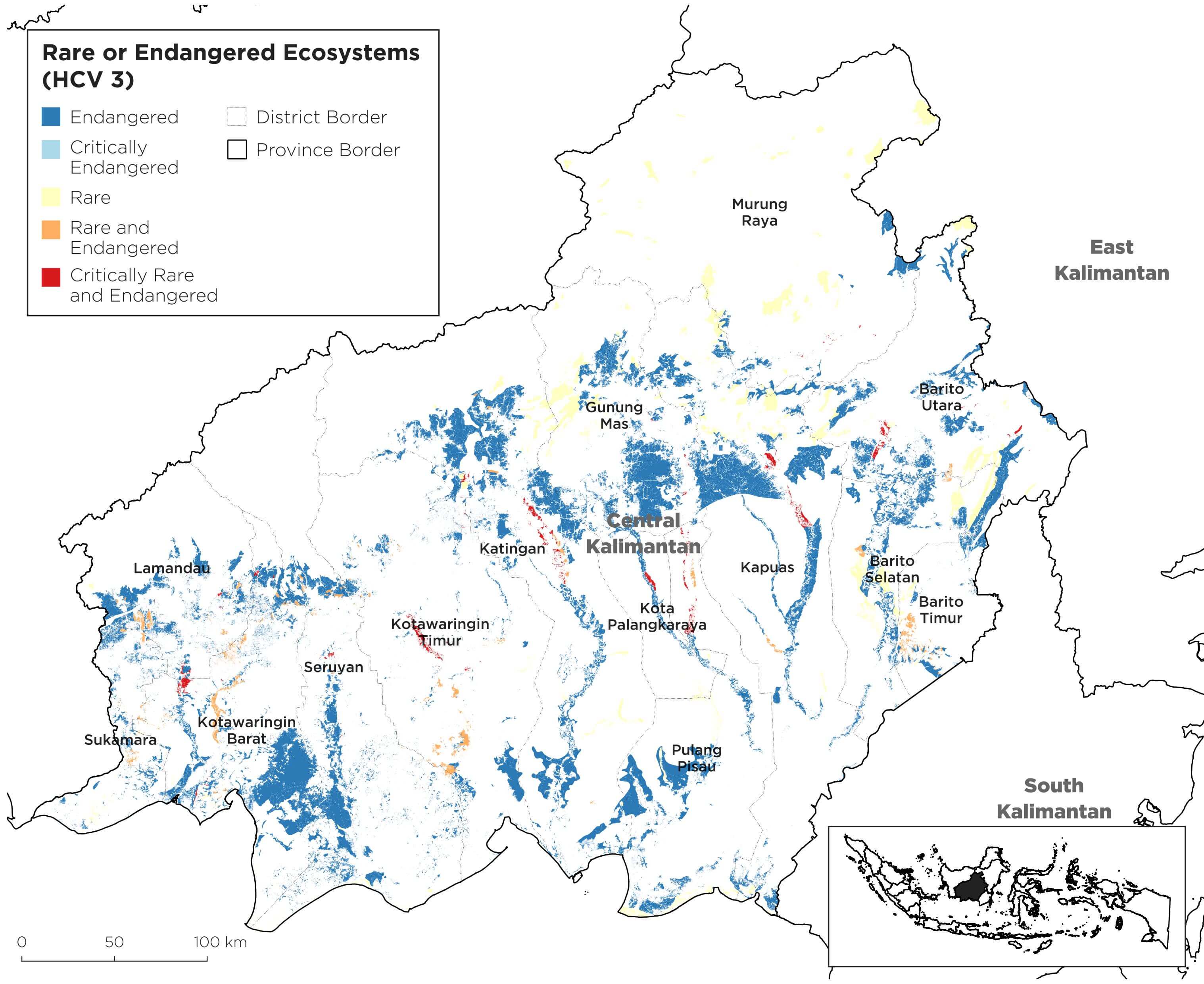
Rare or endangered ecosystems (HCV 3) are less extensive than other HCV areas but present in all districts and cover an estimated 1.73 million ha. They are most extensive in Gunung Mas, Kapuas, and Katingan districts. Significant HCV 3 areas are also present in Seruyan, Kotawaringin Barat, and Barito Utara. In contrast, these areas are more sparse in Murung Raya, where deforestation has been more limited. Endangered ecosystems (purple) are widespread. Critically endangered ecosystems (pink) are found in patches. Rare ecosystems (yellow) occur as strips of alluvial forest along following major rivers. Rare and endangered ecosystems (orange) occur mainly in the southwest. Rare and critically endangered ecosystems (red) are restricted mainly to rare riparian and alluvial zones associated with the major rivers of the province. HCV 3 areas must be prioritized for protection since these ecosystems are already endangered and they are diminishing rapidly.

HCV 3 in Central Kalimantan, Indonesia

Areas at high risk of severe erosion (HCV 4.2) are also extensive, covering nearly 4.5 million ha in Central Kalimantan. These areas have the steep slopes and shallow soils widespread throughout much of the province. The highest risk areas are concentrated in the north, but HCV 4.2 areas also extend southward along dissected sedimentary terraces separating the major north-south running rivers draining the interior of the province. HCV 4.2 mapping highlights that much of Central Kalimantan must be managed carefully to prevent erosion and excessive sedimentation of rivers and waterways.

KEY FINDINGS

Our analysis highlights that Central Kalimantan has a wealth of high value natural landscapes – with important ecosystems covering 60% of the province’s land area. The full extent of HCV areas in the province is no doubt larger than this, and will be identified in the future through supplementary district level and/or project site-level assessments to map other values defined by the HCV approach.

The Districts of Katingan, Murung Raya, Gunung Mas, Kapuas, and Seruyan emerge as notably important owing to the extent of HCV areas present. Murung Raya supports by far the largest area of cumulative HCV, at nearly 2.1 million ha; Katingan ranked in the top three districts for all five HCV types studied. Taken as a group, these top five districts together comprise 56-75% of province-wide area for each HCV category and 62% of total HCV areas overall. This suggests that making progress in these districts to incorporate protection of HCV areas as part of sustainable development planning could lay a solid foundation for balancing environmental and development goals for the province as a whole. Cross district collaboration could help advance this agenda.

hcv-categoriesHigh-value natural landscapes are in decline, particularly forests. Forest cover in Central Kalimantan declined by 4 million ha (or by 32%) between 1973-2012, a rate of nearly 100,000 ha per annum. This change in forest cover was related to a surge of extractive industrial activities starting in the early 1970s. In 2012, remaining forest area was just over 8.1 million ha, equivalent to nearly 50% of the provincial area. Levels of deforestation varied across the province and were most severe in Kotawaringin Timur and Seruyan Districts in the southwest of the province, and the southern and northern parts of Katingan district. Of the 8.1 million ha of remaining forest, we project a risk of further planned deforestation of nearly 1.1 million ha, based on spatial planning and the extent of forested land allocated for conversion. Nearly 62% of mapped HCV areas are potentially threatened with adverse impacts. Planned forest conversion due to spatial planning potentially affects nearly 18% of mapped areas, logging nearly 35%, and fiber and other plantations more than 17%.

RECOMMENDATIONS AND NEXT STEPS

The analysis offers guidance to inform discussions on how to mitigate threats and manage HCV areas through revised development planning, policy making, and impact mitigation measures for specific land uses where one or more HCVs is present. HCV areas identified and mapped in the study will help further inform land management strategies and Strategic Environmental Assessments (Kajian Lingkungan Hidup Strategis or KLHS) as a part of future provincial or district level development policy making and planning processes. Results of the study could help shape management and monitoring plans to maintain or enhance the HCV areas identified, based on an assessment of the major threats to HCV land and options for addressing them.

Part of the management and monitoring plan itself could also be to require site-level assessments to identify and map other site-level HCVs in selected priority areas (e.g. priority districts or concession areas). Specific next steps include:

1. The HCV assessment results will be used as a basis for the Central Kalimantan Production-Protection Working Group to produce recommendations and a policy paper that will be submitted to the Central Kalimantan Government to help support their ongoing sustainable development efforts and to inform policy decisions and development of an HCV area management plan. In light of the new administration and the process of mid-term regional development planning in the province, the HCV assessment could provide a sound scientific foundation for decision making, including for Strategic Environmental Assessment.

2. Building on identification of HCV areas and the 2015 provincial spatial planning plan, Palangka Raya Institute for Land Use and Agricultural Research (PILAR) and Climate Policy Initiative (CPI) have identified the scope and design of a Natural Capital Assessment (NCA) analysis to be conducted at district level to quantify in economic terms these values and other important social values. This work will assist policy makers in making decisions on how to ensure optimum land use in Central Kalimantan to maximize production gains and design appropriate natural resources protection strategies.

3. Combined with the analysis carried out under PILAR-CPI’s other three work streams – including business investment, financial frameworks and mechanisms, and socio-economic benefits – this land use analysis will inform the development of an integrated approach aimed at helping Central Kalimantan to meet its economic development, social and environmental goals concurrently. Through the Production–Protection Approach to Landscape Management (PALM) Program, PILAR and CPI will support government, business and community partners to test the approach at the district level.

up