Accessibility in the Legal Amazon: Delimiting the Area of Influence and Environmental Risks
The Legal Amazon is the most economically isolated region in Brazil. Data indicates that the potential market of a typical municipality in the Amazon is 2.1 times smaller than that of a typical municipality in the rest of the country. The Legal Amazon’s isolation is mostly due to the poor quality and limited coverage of its network of roads, railways, and waterways.
Against such a backdrop, investment in logistics infrastructure is considered essential to improving the Legal Amazon’s ties with domestic and international markets and thus driving the region’s economic growth. Meanwhile, the experience of recent decades suggests that logistics investments in the Legal Amazon encounter implementation challenges and cause considerable socio-environmental damage. These costs affect the cost-benefit analysis of logistics projects in the region. For example, merely the cost of the carbon released by the deforestation that comes with logistics infrastructure projects in the Amazon often exceeds the tax costs associated with implementing the projects.
In this context, it is essential to design public policy that improves accessibility in the Legal Amazon without causing significant environmental degradation. This document discusses how improvements in delimiting the area of influence for logistics infrastructure projects can help mitigate the socio-environmental risks of these projects. It begins by discussing problems with the procedures commonly used to delimit the area of influence for logistics projects. Next it introduces a new methodology for delimiting the area of influence – the market access approach, commonly used in the literature of international trade. It then discusses how better defining of the area of influence contributes to the anticipation and mitigation of a socio-environmental risks. It concludes with recommendations for public policy.
Socio-Environmental Costs of Investment in Logistics
Improvements to logistics infrastructure are essential for reducing isolation and enabling the flow of workers and goods between the Legal Amazon and other parts of Brazil and the world. But logistics infrastructure projects implemented in the region have brought high socio-environmental costs with no significant benefits for local populations.
This is the case for the typical investments in logistics infrastructure in the Legal Amazon over the past three decades, particularly in the road sector. Existing empirical evidence indicates that these investments led to increases in agricultural production in just a few regions (often located outside the Amazon), while imposing widespread socio-environmental costs on the populations located near the projects, and global costs in the form of carbon emissions.
An important dimension of these socio-environmental costs is the increase in deforestation. Improved accessibility fosters land grabbing since it provides an incentive for rural producers to expand their agricultural frontiers, and this considerably increases deforestation in the Legal Amazon. The expansion of frontiers also has a global impact on carbon emissions and biodiversity loss.[1] In addition, deforestation affects the population’s survival and quality of life in numerous ways. The deforestation caused by such projects has consequences for local rainfall regimes,[2],[3] and air pollution from the fires commonly used in the process of deforestation affects infant mortality.[4],[5] Since much of this deforestation is illegal, the projects also have a direct effect on crime,[6] and put pressure on the territories of traditional people and communities.[7] These findings suggest that changes to logistics infrastructure development in the Amazon are fundamental to balancing economic growth, forest conservation, and the protection of traditional people and communities.
Area of Influence and Mapping Socio-Environmental Risks
The area of influence is the area where the economic, social, and environmental dynamic is impacted by the implementation of logistics infrastructure projects. It specifies the communities that must be consulted about a project and that should be the focus of socio-environmental mitigation and compensation measures — measures that are essential for minimizing the socio-environmental costs of logistics infrastructure projects in the Legal Amazon.
Correctly defining the area of influence is thus an important tool for improving the socio-environmental management of logistics infrastructure projects in the region. However, the criteria used in past projects were inconsistent and were typically based on geographic criteria that were not necessarily related to the impact projects had on the economic, social, and environmental dynamics of the various locations. For example, the environmental impact assessments (EIA) prepared for the Midwest Integration Railway (Ferrovia de Integração do Centro-Oeste – FICO, or EF-354) delimit the area of influence based solely on the project’s geographic distance. And the EIAs prepared for the Ferronorte railway project (EF-364) defines the area of influence based on the microbasins that would be crossed by the venture.[8] In light of this, it is crucial to develop methodologies that consider the economic ramifications of implementing logistics infrastructure projects linking multiple markets.
The market access approach, widely used in studies on international trade,[9],[10],[11] offers criteria for defining the area of influence for logistics infrastructure projects. The starting point of this approach is the idea that all the impacts that logistics infrastructure projects have on the economic, social, and environmental dynamic of a region can be summed up in a metric of accessibility called market access. This metric summarizes how a project affects transportation costs in spots that are key to the entry and exit of goods from a region. It can be calculated from estimates of transportation costs between the various regions along with information on their market size. It is then possible to define the area of influence by simply looking at the regions where market access is significantly affected by the implementation of a given project. The market access approach thus provides a transparent and comprehensive starting point for defining area of influence, which can be constructed from the very beginning of a project.
Although the area of influence can always be modified following the conclusion of detailed project assessments, defining an area of influence from the beginning of the project based on criteria that take economic ramifications into account is highly beneficial for minimizing project risk.
In the first place, this delimitation of the area of influence using the market access approach makes it possible to have earlier discussions on mitigation and compensation measures — discussions that currently only happen during the environmental licensing process. With accurate information on the area of influence and project risks, it becomes possible to have these discussions earlier and engage in more thorough debate on the feasibility of each project. The discussions can be bumped up to the feasibility phase, which is already a part of the logistics project cycle, or to a step before the feasibility phase. This has the potential to reduce conflict and allow changes to a project that decreases its socio-environmental impact.
In the second place, instead of using the typical criteria that were based solely on geographic distance, delimiting the area of influence using the market access approach facilitates the consultation process for populations potentially impacted by a project. This process is provided for in both Brazilian legislation and international conventions and is essential for giving a voice to affected communities, reducing conflict, and allowing those affected to propose changes that mitigate and compensate for a project’s impacts.[12]
The Case of BR-319
The BR-319 highway, which links the municipalities of Porto Velho (Rondônia state) and Manaus (Amazonas state), was built in the 1970s. However, due to lack of maintenance, by the end of the 1980s long unpaved stretches of the highway were impassable. In recent years, rebuilding this highway has become one of the federal government’s planned investments in the Legal Amazon.
The market access approach can be used to delimit the area of influence for this project. The case of the BR-319 highway offers an example of the potential this methodology has to identify risks, steer consultation processes, and promote debate on measures to mitigate the impact of logistics infrastructure projects. Data indicate that the construction of BR-319 will affect a total of nine municipalities located within the state of Amazonas.[13] These municipalities have a population of over 320,000 residents and cover an area of more than 300,000 km2. Using a criterion of fixed distance from the path of the project, the area of influence could vary between 7,600 km2 (if the distances were 10 km, as specified in the EIA of EF-364) and 38,000 km2 (if the distances were 50 km, as specified in the EIA of EF-354).
The impact that paving this road has on market access changes in a non-linear fashion depending on the distance from the project and is not uniform across the entire project (Figure 1). This means that the market access approach allows for not only a more realistic delimitation of the area of influence but also for the identification of areas that are more or less impacted within an area of influence.
Figure 1. Access to Market in the Area of Influence of BR-319
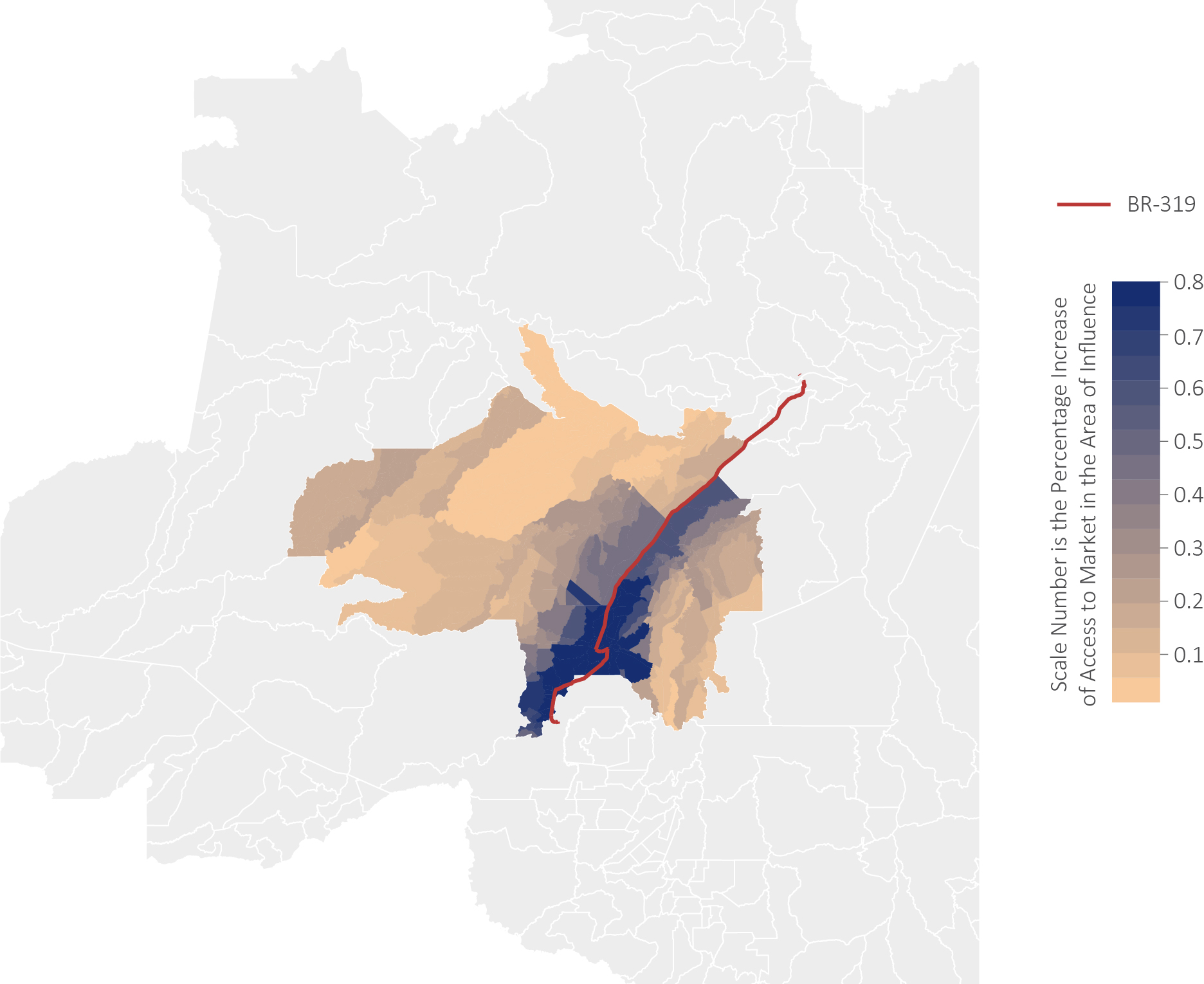
Source: CPI/PUC-Rio with data from Ministry of Infrastructure, Demographic Census (IBGE), and SIFRECA/ESALq, 2022
In all, the area of influence of BR-319 encompasses 49 indigenous territories, 49 conservation units and over 140,000 km2 of undesignated public forest (Figure 2). These data demonstrate the importance of consulting the populations that could be affected, as well as designating undesignated forests and implementing land governance and command and control measures that strengthen the protection of conservation units in the region. The possibility to identify risks, affected populations, and potential mitigation measures from the beginning of the project’s life cycle provides an opportunity to improve investment decisions for logistics infrastructure, thus reducing risks, avoiding conflict, and guaranteeing the proper use of public resources.
Figure 2. Area of Influence, Protected Areas, and Non Designated Public Forests around BR-319
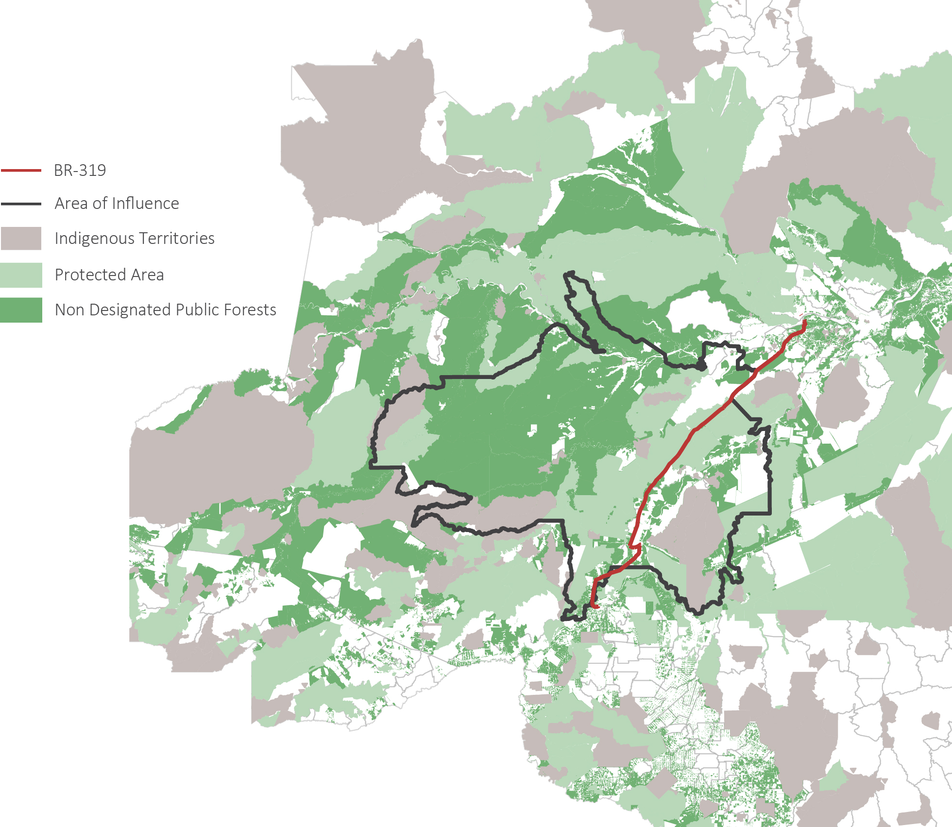
Source: CPI/PUC-Rio with data from Ministry of Infrastructure, Demographic Census (IBGE), SIFRECA/ESALq, and Ministry of the Environment, 2022
Conclusion and Recommendations for Public Policy
This document discusses how better defining of the area of influence for logistics infrastructure projects can help mitigate the socio-environmental damage caused by their implementation. Using a market access approach developed by researchers at Climate Policy Initiative/Pontifical Catholic University of Rio de Janeiro (CPI/PUC-Rio), it discusses how using transparent methodologies can be helpful for identifying risks, steering consultation procedures toward the populations that might be affected and designing compensation and mitigation measures.
Regulatory changes that promote more transparency in the criteria and methodologies for delimiting area of influence and allow for earlier discussion of socio-environmental issues can be important tools for improving the governance of logistics infrastructure projects and thus for improving these projects’ cost-benefit ratio for society. Specifically, the following three proposals would help improve project governance:
- The Ministry of Infrastructure should require socio-environmental risks to be assessed at the beginning of the project’s life cycle.
- The Ministry of Infrastructure and associated bodies should define a methodology that allows the area of influence for logistics infrastructure projects to be calculated using information in the public domain. This methodology should include data and codes that are available to the public to reduce the discretion that currently exists in delimiting direct and indirect areas of influence.
- The Ministry of Infrastructure and associated bodies should build and maintain an up-to-date geographic information system (GIS) with all the territorial information—from both existing and projected infrastructure—needed to calculate the area of influence for logistics infrastructure projects being considered in the National Logistics Plan (Plano Nacional de Logística – PNL).
[1] Ferraz, Gonçalo, Gareth J. Russell, Philip C. Stouffer, Richard O. Bierregaard, Stuart L. Pimm, and Thomas E. Lovejoy. “Rates of species loss from Amazonian forest fragments”. Proceedings of the National Academy of Sciences 100, no. 24 (2003): 14069-14073.
[2] Spracklen, Dominick V., S. R. Arnold, and C.M. Taylor. “Observations of Increased Tropical Rainfall Preceded by Air Passage Over Forests”. Nature 489, no. 7415 (2012): 282-285.
[3] Araujo, Rafael. Mapping the Effects of Deforestation on Rainfall: A Case Study on the State of Mato Grosso. Rio de Janeiro: Climate Policy Initiative, 2021.
[4] Rocha, Rudi and André A. Sant’Anna. “Winds of Fire and Smoke: Air Pollution and Health in the Brazilian Amazon”. World Development 151 (2022).
[5] Rangel, Marcos A. and Tom S. Vogl. “Agricultural fires and health at birth”. Review of Economics and Statistics101, no. 4 (2019): 616-630.
[6] Chimeli, Ariaster B., and Rodrigo R. Soares. “The Use of Violence in Illegal Markets: Evidence from Mahogany Trade in the Brazilian Amazon”. American Economic Journal: Applied Economics 9, no. 4 (2019): 30-57.
[7] Fetzer, Thiemo and Samuel Marden. “Take What You Can: Property Rights, Contestability and Conflict”. The Economic Journal 127, no. 601 (2017): 757-783.
[8] Antonaccio, Luiza, Ana Cristina Barros, Arthur Bragança, and Joana Chiavari. The Need to Better Define and Delimit Area of Influence for Infrastructure Projects.Rio de Janeiro: Climate Policy Initiative, 2020.
[9] Eaton, Jonathan and Samuel Kortum. “Technology, Geography, and Trade”. Econometrica 70, no. 5 (2002): 1741-1779.
[10] Redding, Stephen and Anthony J. Venables. “Economic Geography and International Inequality”. Journal of International Economics 62, no. 1 (2004): 53-82.
[11] Donaldson, Dave and Richard Hornbeck. “Railroads and American Economic Growth: A ´Market Access´ Approach”. The Quarterly Journal of Economics 131, no. 2 (2016): 799-858.
[12] For example, Convention no. 169 of the International Labor Organization. See more in Garzón, Biviany R. et al. Recomendações para aplicação do direito de Consulta Livre, Prévia e Informada. Brasília: Instituto Socioambiental, 2021.
[13] The municipalities are: Anori, Beruri, Canutama, Carauari, Coari, Humaitá, Manicoré, Tapauá, and Tefé.
